Mostrando entradas con la etiqueta Bosques. Mostrar todas las entradas

miércoles, 12 de marzo de 2014

¡Comprenda, los bosques son más que madera!

10 servicios de los bosques que debemos conocer.

¡Comprenda, los bosques son más que madera!

El concepto de Servicios Ecosistémicos se refiere a los beneficios obtenidos directa o indirectamente por la biodiversidad. Los servicios directos incluyen recursos como el agua, que depende para su calidad y regulación de la conservación de los bosques en las cuencas abastecedoras. Los alimentos obtenidos directamente de plantas cultivadas o silvestres. Por su parte, los servicios indirectos comprenden otros beneficios como la regulación del clima, el control de la erosión, la recreación y la polinización.

Según algunos estudios recientes, el valor real de todos los servicios ecosistémicos es inmenso y supera el total del producto interno bruto mundial, por ejemplo, el valor global estimado para el servicio de polinización puede alcanza cifras tan grandes como 153 mil millones de euros por año.

Aquí les presentamos 10 servicios de los bosques que debemos conocer.


¿Cómo se beneficia la sociedad con los servicios ecosistémicos?

Abastecimiento

  • Alimentos
  • Agua Potable
  • Madera y Fibras
  • Combustibles 
Reguladores

  • Control climático
  • Control de inundaciones
  • Control de enfermedades
  • Purificación del agua 
Cultural

  • Estético
  • Espiritual
  • Educacional
  • Recreativo
Desde hace algunos años, el Jardín Botánico de Medellín viene realizando investigaciones que se enmarcan en el tema de la conservación de la biodiversidad y el cambio climático. Actualmente, cuenta con un laboratorio de investigación SECC (Servicios Ecosistémicos y Cambio Climático) que entre otras actividades, también ofrece un portafolio de servicios.

Grupo de investigación en servicios ecosistémicos y cambio climático - SECC

Líneas de investigación
  1. Cambio climático y ecosistemas tropicales
  2. Conocimiento y uso tradicional de la biodiversidad
  3. Conocimiento, modelación y monitoreo de la biodiversidad
  4. Contenido y flujos de carbono de los bosques tropicales
  5. Restauración de ecosistemas
  6. Servicios ecosistémicos y ecología del árbol Urbano
  7. Valoración de servicios ecosistémicos.
 
Bosques, servicios ecosistémicos y cambio climático

Desde hace algunos años, el Jardín Botánico de Medellín viene realizando investigaciones que se enmarcan en el tema de la conservación de la biodiversidad y el cambio climático.

Es líder en el tema del monitoreo del bosque y ha generado gran parte de la información sobre dinámica y diversidad a partir de parcelas permanentes de vegetación. Avanza en la investigación de energía alternativas mediante la identificación y domesticación de especies de plantas nativas de Colombia con alto potencial para la producción de biocombustibles.

En la actualidad, los jardines botánicos están encontrando nuevos usos para las herramientas tradicionales de investigación, como la información contenida en los especímenes de herbario y las fotografías históricas, que son cada vez más utilizados para obtener información sobre el comportamiento de las plantas en el pasado. El trabajo adicional sobre especies invasoras y los estudios comparativos de las respuestas a las variaciones climáticas están proporcionando puntos de vista sobre importantes cuestiones ecológicas, evolutivas y de manejo de las plantas. Con sus grandes colecciones vivas y de herbario especies de plantas de todo el mundo, los jardines botánicos están bien posicionados para expandir sus actividades con el objetivo de liderar la investigación y la educación sobre el cambio climático y la educación.

Portafolio de servicios

lunes, 3 de marzo de 2014

El mapa que explica la deforestación en el mundo (y lo hace en tiempo real)

Varios organismos lanzan Global Forest Watch, una web que integra capas de datos para ver el estado de los bosques de todo el mundo

Los mapas los pone Google; las imágenes de satélite, la NASA; los datos, el World Resources Institute y otras agencias; y la capa de visualización, la empresa española Vizzuality

El recurso sirve para gobiernos, empresas, comunidades y para que cualquier ciudadano explore los cambios forestales casi según suceden, porque los datos se actualizan con frecuencia

 Global Forest Watch.


Mira el mapa. El rosa representa la masa forestal que ha desaparecido en España desde el año 2000. ¿Qué pasa en Galicia, que se ha perdido tanta? "Muy fácil: en Galicia se producen el 50% de incendios de España", responde Ángel Dorrio, técnico de Medioambiente de la asociación Amigos da Terra.

Las estadísticas del Ministerio de Agricultura y el mapa de España en Llamas confirman que Galicia es la comunidad en la que más hay. "Como ves, siempre aparece Galicia en rojo. Los datos son graves, llevamos más de cuarenta años con el mismo problema". Un caso reciente es el de las Fragas do Eume. Si hacemos zum, vemos con detalle la zona devastada. La captura de la izquierda es el parque entre 2005 y 2009; la de la derecha, entre 2005 y 2013. En abril de 2012, el incendio extinguió más de 750 hectáreas (que son las que aparecen en rosa).


Ahora mira esta otra imagen:


Es una de las áreas del mundo en la que más árboles desaparecen. Aunque la del Amazonas es la más sonada, lo de arriba es el zum sobre la región de Gran Chaco, entre el sur de Brasil, Argentina y Paraguay. ¿Qué pasa? ¿Por qué la deforestación allí es cuadrada? Se llama sojización y es el cultivo de soja. "En Argentina y Brasil ha crecido brutalmente. Sustituyen cultivos tradicionales por monocultivo y hay mucha deforestación", explica Tom Kucharz, de Ecologistas en Acción.

¿Y por qué soja? Es más barata ("es agricultura intensiva con muchísima tecnología y fertilizantes químicos para matar la mala hierba"), sus proteínas son perfectas para la ganadería industrial (la que usan las cadenas de comida rápida, por ejemplo) y se vende muy bien en los mercados internacionales.

Este gráfico muestra la evolución de su precio, que sólo de 2007 a 2008 subió un 86%. Como Kucharz, ecologistas e investigadores llevan años alertando sobre el problema y sus efectos económicos y sociales. También sobre los medioambientales, claro.

Pintar los cambios de los bosques

Galicia y sus incendios, y el Gran Chaco y su sojización son sólo dos de los casos de deforestación que hay en el mundo. Las imágenes para explicarlos las hemos sacado de Global Forest Watch, un proyecto del World Resources Institute presentado la semana pasada que, en forma de web, muestra el estado de los bosques del mundo.

Los mapas los pone Google; los datos de árboles desaparecidos y aparecidos e imágenes de satélite, organismos como la Universidad de Maryland o la NASA. Y la visualización de esos datos (o cómo ver, en una imagen, que los incendios forestales en Galicia o los cultivos de soja se cargan los bosques), la empresa española Vizzuality y su tecnología CartoDB (que en eldiario.es hemos utilizado, por ejemplo, para ver el tráfico ferroviario en España).

"Lo que nos gusta es contar historias y los mapas son un medio para ello", explica Carlos Matallín, uno de los desarrolladores que ha ‘pintado’ las capas de datos. "Tenemos datos muy ricos, importantes y validados, pero que no puedes tirar en crudo porque no se saca nada en claro. Puedes decir ‘sí, hay deforestación’. La parte bonita, interesante y compleja es cómo muestro estos datos a cualquier persona de forma amigable e intuitiva. Y con ello, contar, por ejemplo, la deforestación en un área protegida y cómo a través de las alertas se puede parar". ¿Alertas?


Si un árbol cae y nadie lo escucha, ¿hace ruido?

Un problema de la deforestación es que cuando se detecta (cuando el árbol cae en mitad del bosque) suele ser tarde para pararla. Por eso la novedad de Global Forest Watch, que lleva dos años en desarrollo y del que ha habido prototipos previos, es el tiempo real: los datos que integra no sólo son de muy buena calidad (aquí explican de dónde proviene cada set de datos y cómo se ha tomado), sino que en muchos casos se actualizan diaria o mensualmente. También la posibilidad de delimitar áreas, guardarlas y poner alertas que te avisen si 'algo' cambia (si algún árbol cae en mitad del bosque).

.

"La página dice: 'near real time' (casi en tiempo real). La capa de fuegos, por ejemplo, se puede tener con hasta un día de diferencia. En cada capa están explicadas la resolución de los datos y la periodicidad con la que se actualizan", cuenta Matallín. Las capas más importantes son las de Forest Change (el cambio en los bosques, que dentro de la web está en la columna de la izquierda). "Queremos saber cómo está cambiando el bosque y eso viene explicado ahí. El resto de las capas (biodiversidad, masa forestal, zonas intactas o protegidas) ayudan al análisis".

Haciendo zoom, activando y desactivando capas de datos, puedes encontrar historias de deforestación o reforestación. Además de los incendios gallegos o sojización, en este post hay otros nueve ejemplos para entender lo que pasa en los bosques del mundo.

Rompiendo la barrera entre la ciencia y las personas

Más allá del ‘wow, qué mapa tan vistoso’, la herramienta es útil para muchos agentes. "Sirve para diferentes tipos de personas que quieran trabajar con los datos. Agencias gubernamentales, o no, que quieran controlar la deforestación, grupos indígenas que quieran saber qué está pasando con su tierra o empresas que quieren asegurarse de que su cadena de distribución cumple con los compromisos", precisa Matallín.

"Digamos Unilever o Nestlé, que son empresas que han dado su nombre. Nestlé tiene proveedores que están explotando un área. Ellos pueden ir a esa zona, hacer un análisis y confirmar que lo que les han dicho sus proveedores coincide con lo que ellos ven a través de la web".

Y más allá de gobiernos, empresas y grandes organizaciones, el objetivo de Global Forest Watch es llegar a la gente: con la posibilidad de enviar historias para explicar, con fotos, palabras y ejemplos, qué pasa en los bosques del mundo (¿hay un incendio en Valencia?, ¿en la isla de Sumatra? Envíaselo para que aparezca sobre el mapa) y que cualquier ciudadano lo explore.

"Con los datos en números no haces nada. Con esto acercas un poco más, o ayudas a romper la barrera que hay entre la ciencia y las personas. Que, al fin y al cabo, es lo importante y realmente crucial de este proyecto".

ORIGINAL: El Diario (España)
Analía Plaza
02/03/2014

lunes, 3 de febrero de 2014

Global Forest Change


Results from time-series analysis of 654,178 Landsat images in characterizing forest extent and change, 2000–2012.

Trees are defined as all vegetation taller than 5m in height and are expressed as a percentage per output grid cell as ‘2000 Percent Tree Cover’. ‘Forest Loss’ is defined as a stand-replacement disturbance, or a change from a forest to non-forest state. ‘Forest Gain’ is defined as the inverse of loss, or a non-forest to forest change entirely within the study period. ‘Forest Loss Year’ is a disaggregation of total ‘Forest Loss’ to annual time scales.

Reference 2000 and 2012 imagery are median observations from a set of quality assessment-passed growing season observations.

ORIGINAL: Earth Engine Partners

by Hansen, Potapov, Moore, Hancher et al.

viernes, 15 de marzo de 2013

Resurrecting A Forest

ORIGINAL: NatGeo
by Carl Zimmer


For the cover story in the April 2013 issue of National Geographic, I explore an idea that sounds like pure science fiction: bringing extinct species back to life. What was once the purely the domain of Crichton and Spielberg is becoming a new field of research. Thanks to spectacular advances in cloning, reproductive technology, and DNA sequencing, scientists can now seriously explore the possibility of reviving some species from extinction. If not dinosaurs, then perhaps mammoths or passenger pigeons.

“De-extinction,” as its advocates sometimes call it, is part of a bigger trend these days in the world of conservation. Over the past five decades, conservation has usually taken the form of removing threats so that endangered species can recover–ban pollutants, protect habitats, stop hunting, and the like. Conservationists saved the brown pelican, for example, by protecting it from DDT and similar chemicals and by preserving the coastal wetlands where it lives. What they did not do, however, was tinker with brown pelican DNA to make the birds better able to survive. Indeed, the brown pelican gene pool–the product of millions of years of evolution before humans turned up–was ultimately what the scientists were trying to protect from oblivion.

Meanwhile, over those same five decades, molecular biologists have become adept at probing and manipulating genes. Sequencing genomes went from a dream to just another day’s work at the lab. In the 1970s, scientists began inserting genes from one species into another, and they can now build simple genetic circuits.

Conservation biologists have taken up many of these tools. They learned how to sequence DNA, for example, so that they could map populations of endangered species and track the flow of genes between them. They’ve used advanced reproductive technology to raise their success rate with captive breeding programs. The San Diego Zoo has frozen stem cells and tissues from thousands of species of animals to investigate for new ways to conserve them in the wild.

But conservation biologists have also seen some risks to biotechnology. If a synthetic organism could establish itself in the wild, for example, it could become an invasive species, putting native species at risk. (It’s important to point out that there’s no evidence that such an invasion has happened yet.) If we think of biodiversity as the world’s storehouse of genetic variation, then biotechnology has the potential to drive it down. Genetically engineered plants or animals might interbreed with wild relatives and spread their modified genes into the environment, reducing genetic variation in the wild.

Despite the potential risks, a number of conservation biologists are gingerly considering making even greater uses of biotechnology in order to protect biodiversity. Next month, for example, the Wildlife Conservation Society is hosting a meeting called “How Will Synthetic Biology and Conservation Shape the Future of Nature?”

Here’s a passage from the meeting’s framing statement:
“Critics have focused on the threats posed by novel life forms released into the environment, but little attention is paid to potential opportunities–to reconstruct extinct species or create customized ecological communities designed to produce ecosystem services. They may change the public perception of what is “natural” and certainly challenge the notion of evolution as a process beyond human construction.”
One of the few surviving American chestnuts, located in Maine. Photo courtesy of William Powell
One of the few surviving American chestnuts,
located in Maine.
Photo courtesy of William Powell

To me, there’s no better example of the ambiguous future of conservation biology than the story of the American chestnut.

When Europeans arrived in North America, they found forests filled with American chestnut trees. These mighty plants, which could grow to be 100 feet tall, were the most abundant trees in the forests, making up 25 percent of the standing timber of the eastern United States. In the summer, the peaks of Appalachian mountains appeared to be capped with snow, thanks to the explosion of white chestnut flowers. Chestnut trees anchored the ecosystems of eastern American forests, providing food and shelter to bears, Carolina parakeets, and a vast number of other species. They were also a mainstay of loggers, who could fill an entire train car with boards cut from a single tree.

In 1904, a scientist observed that a chestnut tree at the Bronx Zoo was dying. It turned out to be infected with a fungus that came to be known as chestnut blight. No one is quite sure how it got to the United States, but all the evidence we have indicates it hitch-hiked its way in the 1870s on chestnut trees imported from Japan.

Chestnut blight, while harmless to Asian trees, proved devastating to the American ones. The fungi released a toxic substance called oxalic acid that killed off the tissue, allowing them to feed on it. An infected tree developed cankers on its trunk, and once they spread around the full circumference of a tree, it could no longer carry water and nutrients from its roots to its branches.
A stand of blight-infected chestnuts in New York, 1915. Courtesy of William Powell
Over the course of about eighty years, the chestnut blight spread across almost the entire range of the American chestnut, from Maine to Missippi. It conquered nine million acres and infected three billion trees. A few lone trees still survive unharmed here and there, but no one under the age of sixty has ever seen the forests of the eastern United States as they once were.

In the pantheon of extinction, American chestnuts are poised awkwardly at the door. Chestnut blight doesn’t kill the trees outright; as it spreads down to the roots, it encounters other microbes that outcompete it. As a result, infected trees become stumps. Sometimes they send up a new shoot, but once it reaches a few feet in height, the fungus attacks it again, and the shoot dies back.

“It’s basically functionally dead,” William Powell of SUNY College of Environmental Science and Forestry in Syracuse, New York, told me. “They sprout up, they get the blight again, and they are killed down to the ground. You know the story of Sisyphus? The guy who rolled the rock up the hill and it just kept rolling back down? Well, that’s kind of like what’s happening with the chestnut.”

It’s been a century since American foresters started trying to save the tree. They sprayed the trees with fungicial chemicals, to no avail. They infected the blight with fungus-invading viruses, but resistant strains continued to kill trees. They tried burning down chestnut trees to create a fungal firebreak, only to discover that the blight could silently infect oak trees, too.

They did what conservationists have always done–try to remove the threat–but nothing worked.
In the 1980s, a group of scientists embarked on a different approach, one that is now showing signs of success. If they couldn’t stop the blight, they would help the trees defend themselves.

The reason that chestnut blight was able to come to America in the first place was that Asian chestnuts can fight the fungus. They have genes that allow them to hold the cankers in check and scar them over. The trees can continue to grow and produce pollen and seeds. American chestnuts, evolving thousands of miles across the Pacific, never got the opportunity to evolve defenses against the blight. So the American Chestnut Foundation, a non-profit established to save the tree, decided to start breeding the two trees together, to see if they could provide the American chestnuts with Asian defenses.

When the foundation’s scientists interbred the American and Asian trees, the plants mixed together their genes in different combinations in their hybrid seeds. The scientists grew the seeds into saplings, and after a few years, it became clear that some of the hybird chestnuts had inherited some of the Asian defense genes. The cankers grew more slowly on them than on their American ancestors.

But the trees were no longer recognizable as American chestnuts, since half of their DNA came from Asian chestnuts. Asian chestnuts are small, orchard-like trees, and so the hybrids were far smaller than their towering American ancestors. These hybrids were not the solution to the chestnut blight, in other words. Their defenses were still weak, and they would not survive in American forests in the shadow of oaks and other big trees.

So the scientists kept breeding the trees. They used another tried-and-true method, known as backcrossing. They bred the American-Asian hybrids with American chestnuts, producing trees with only a quarter of their DNA coming from Asian chestnuts. Again, some of the new trees could resist the blight, while the others couldn’t. That was because the quarter of their DNA from the Asian trees contained the genes essential for fighting the disease. At the same time, the trees more closely resembled American chestnuts, because they inherited more of their DNA.

From this generation, the scientists picked the best-defended trees and back-crossed them again. They also mated hybrids with one another, shuffling the genes into new combinations, and selectively breeding the chestnuts that were both more resistant and bigger. They’ve now got thousands of trees that are 15 parts American and one part Asian growing on their experimental farm in Virginia.

A diagram of backcrossing experiments. American Chestnut Foundation

That one-sixteenth of Asian chestnut DNA may not sound like a lot, but it is. “There are thousands of genes in there,” says Powell. For all we know, some of those genes may impair the success of chestnuts in American forests. “It’s better to be precise about the genes you put in,” Powell argues. Working with the American Chestnut Foundation, he and his colleagues have developed a surgical approach to breeding resistant chestnut trees.

In 1990, Powell and some colleagues started investigating how to move single genes into American chestnuts. It took years to get the project off the ground. You can’t insert genes into a tree simply by sticking a needle into a trunk. Genes can only be inserted into individual cells. So Powell and his colleagues had to figure out how to rear chestnuts in their lab.

Some plants can survive as cells in a lab forever. But chestnuts are not one of those plants. Powell and his colleagues found that they had to combine pollen and ovules to produce embryos. With just the right concentration of hormones, the embryos bud off more embryos, which bud off embryos in turn. The scientists can then pick off individual embryonic cells, insert genes into the, and then grow the cells into full-blown chestnut trees.

After figuring all of this out, the scientists began to search for genes to insert into the chestnut cells. At the time, no one had mapped Chinese chestnut genes, so Powell and his colleagues turned to better studied plants. Plant scientists had figured out how wheat fights fungi, making enzymes that chop up the oxyalic acid into harmless byproducts. Powell and his colleagues inserted the wheat gene for the enzyme into chestnut cells and then grew the cells into trees.

At first the enzyme wasn’t much help, so the scientists fine-tuned the genes so that the chestnuts made more of it. The more oxalic acid they made, the better they fought the chestnut blight. The scientists eventually produced trees that could limit the cankers and heal them over.

William Powell inspects American chestnuts with blight-inhibting enzymes. Photo: Syracuse University

Last spring, the New York Botanic Gardens planted a few of the chestnuts for public display. (You can see the video of the ceremony here.) You can go to the gardens now and can see for yourself that the trees are growing and thriving, despite being exposed to chestnut blight spores wafting by. “We want to do everything transparently,” says Powell. “We don’t want people to think we’re hiding anything here.”

It may be five years or longer before these trees start growing in the wild. Powell and his colleagues need to spend a couple more years collecting data before submitting an application to the U.S. Department of Agriculture, and then the Environmental Protection Agency has to sign off on the project. Even the Food and Drug Administration will have to get in on the act, because the trees will produce nuts that people might eat.

But the trees growing in the Bronx are not the final version Powell hopes to see reviving America’s forests. It’s now finally possible for him and his colleagues to explore the Chinese chestnut tree genome, and so they’ve started  hunting for blight resistance genes. One gene for chopping up oxalic acid won’t be enough to provide full resistance, Powell suspects. He’s pretty sure that Chinese chestnut trees have evolved a number of genes that together render the blight harmless.

Adding in extra genes is essential, Powell believes, because the chestnut blight is not a fixed target. It is evolving, and it will probably be easy for it to evolve its way around just one line of defense. Each tree will need to be equipped for many attacks from evolved pathogens over the course of its lifetime, which can be as long as a century. Powell suspects a few genes will provide a durable defense, but he can’t say for sure which genes those are. So far, he and his colleagues have identified a list of candidate genes in Chinese chestnuts. “We’ve narrowed it down to about 900 now,” Powell told me with a laugh.

If, a century from now, Powell’s chestnuts tower once again over the eastern United States, how will we think of those forests? Will we think of them as nature restored to its former glory, ecosystems thriving once more? Or will we think of them as unnatural, the product of human tinkering? Or both? Given the past century of struggle to save the chestnut, the choice here is not natural versus unnatural. It’s chestnuts versus no chestnuts. “It’s not going to fix itself,” says Powell.
____________
(Update, 3/12: I got a good question on Twitter when I pointed readers to this post:


There are indeed companies developing patented genetically modified trees. This article in the Guardian in November describes a company that has produced a eucalyptus tree that can grow faster and produce more wood, which could be raised in plantations. Environmental groups like the Sierra Club have criticized  this research because of the potential environmental damage it might lead to and called for a moratorium.

Powell and his colleagues have not patented their chestnut trees, however, nor do they have any plans to do so. As I wrote above, they’re searching for additional genes for resistance, and they’ve avoided patented ones as much as possible. Once they have figured out which genes they need to use, they will do a complete patent search. If the genes do turn out to be patented, they’ll ask the patent holders for a license for free use. “I view this as a not-for-profit endeavor,” says Powell.)

____________
Powell and I will both be among the speakers at TEDxDeExtinction, taking place at the National Geographic Society in Washington DC this Friday. You can buy tickets to the all-day event here, or watch it livestreamed for free here. My story for National Geographic will be available online on Friday as well. For more information, visit National Geographic’s DeExtinction Hub.

viernes, 18 de enero de 2013

Protecting global water sources

ORIGINAL: TicoTimes
By Alberto Font
Friday, January 18, 2013 - 

A study by research group Ecosystem Marketplace noted that 80 percent of the world’s countries are facing issues related to threatened water security.
Dave Sherwood
A new study finds that the number of global environmental services programs doubled from 2008-2011.

A report released this week finds that more countries are turning to environmental services programs to protect sensitive water sources.

Facing increasing water scarcity, many countries are turning to environmental service payments to help mitigate the effects of climate change and pollution. 

A study released this week by research group Ecosystem Marketplace, titled “State of Water Resource Protection 2012,” noted that 80 percent of the world’s countries are facing issues related to threatened water security. 

“We are witnessing the first stages of a global response that could transform the ways in which we value and manage the world’s hydrologic resources,” said Michael Jenkins, CEO of Forest Trends, a conservation group that manages Ecosystem Marketplace.  (Charting New Waters State of Watershed Payments 2012)

According to Marta Echavarría, a member of Ecosystem Marketplace’s advisory committee, Costa Rica, is a pioneer of environmental service payment programs, established in the 1990s with the creation of the National Forestry Financing Fund, which provides landowners with financial incentives to protect forested areas. 

Other countries in the region, including Mexico, Ecuador, Brazil and Bolivia, have created similar programs, sometimes offering non-financial incentives. In Bolivia, for example, more than 500 families receive bee farms, fruit trees or other productive input in exchange for efforts to protect water sources. Ecuador pays farmers and indigenous communities to protect their hydrologic resources. 

From 2008 to 2011, initiatives to protect and restore forests, wetlands and other important ecosystems have doubled in number. The report covers 205 programs around the world, 21 of them in Latin America. Globally, the number of programs has increased by 100 in three years, totaling $8.2 billion in investment, a significantly greater amount than in 2008. 

Ecosystem Marketplace analysts noted that investing in programs to protect water at the source, rather than spending on treatment, could result in considerable savings for governments. It also helps to guarantee water security and provide environmental and social benefits to communities. 

“[These programs] definitely curb costs. If we don’t look for natural alternatives, eventually we’re going to have to invest heavily in building large water treatment plants or in transporting potable water long distances,” Echavarría told The Tico Times.

Another problem Latin Americans face is a general lack of water treatment infrastructure. Coupled with the effects of pollution and climate change, the lack of treatment facilities is converting a region rich in hydrologic resources into one that is highly vulnerable to problems with accessing potable water. 

The study notes that China is a global leader in investing in programs to protect hydrologic resources at the source. The Asian giant accounts for 91 percent of global investments in environmental services programs protecting water. Chinese officials, for example, offer new health service benefits for residents in mountainous communities in exchange for better groundwater management, which they say will help improve potable water access.

“The lack of secure water sources likely represents the greatest threat for continued economic growth [in China],” the report noted. 

In the United States, officials in New York chose not to invest heavily in new water treatment facilities, opting instead to implement compensation programs for farmers in the Catskills who agreed to work to reduce pollution in regional lakes, rivers and streams that provide New York City with potable water. Thanks to these efforts, New York had enough drinking water to make it through the recent Hurricane Sandy.

The study also notes that 68 other environmental services programs operate in all of North America. 

“The benefits of these hydrologic programs extend well beyond water; they support biodiversity, reduce emissions and provide income to rural families,” said Genevieve Bennett, the report’s lead author.

But private-sector participation in these types of programs remains limited, despite the fact that many companies have reported problems related to water availability. Most of these types of programs are operated by nongovernmental organizations or by governments. 

“It could very well be that many companies are taking a wait-and-see approach to see if these programs can be improved upon,” Bennett said. 

But Bennett believes that the market for hydrologic services investment is on the verge of considerable growth, particularly if the global economy begins to improve. 

“The best part of this report is that it tells us that these types of investments are real, they’re growing, and they don’t follow ideological lines. Countries with a neoliberal philosophy are implementing them along with capitalist countries and communist countries like China. We all have to protect our water sources,” Echavarría said.

miércoles, 17 de octubre de 2012

New Handbook Helps Propagate Fungi Livelihoods that Reduce Pressures on Forests

ORIGINAL: RECOFT

Program participants package their mushroom harvests
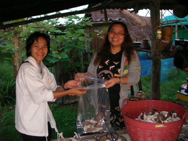
Organic mushrooms may seem like an unlikely solution to poaching and illegal logging, but Freeland Foundation is championing this low-impact crop as a viable eco-friendly option for villagers living around protected areas in Northeastern Thailand. With support from the U.S. Fish and Wildlife Service, Freeland’s Surviving Together program is training former poachers to cultivate organic mushrooms, then seeding and nurturing their businesses with small loans, wholesaling and marketing support.

Many individuals have benefited from the program and are now able to make their living in a sustainable manner. As one graduate of Freeland’s training program, Boonrod Muangchan, says: “Once I started my own business growing mushrooms I started to get a steady income. I love the forest, I want to protect it. I feel sorry for what I did in the past.”

Drawing on the knowledge of its Thai trainers, Surviving Together has just published a practical guide to growing mushrooms organically. Available in Thai and English, the manual covers topics from nurturing spores and building barns, to dealing with pests without chemicals, and recycling materials. This publication is designed to help spread the uptake and benefits of sustainable, low-impact, organic agriculture.
Stocking the mushroom barn.
Organic Oyster, Shitake and Yanagi mushrooms being sold at local markets are in such high demand that farmers simply can’t grow enough. Freeland is trying to increase sales to higher value urban markets in Bangkok, banking on restaurants and consumers willing to support organic produce that helps conserve nature and alleviate rural poverty.

The pilot has been successful in propagating forest-friendly alternative livelihoods and measurably reducing poaching in nearby forests. It was even highlighted as a top global sustainability solution at the Rio+20 conference in Brazil earlier this year.

Freeland is seeking partners and sources of micro-finance to help replicate the successful pilot along the border of the vast Dong Phayayen-Khao Yai Forest Complex and around other vulnerable landscapes in Thailand and neighboring countries.

Check out this video to hear more from the program participants.


For more info and to stay up-to-date, follow the Khao Yai Experience.

lunes, 17 de septiembre de 2012

'Nuestro oro es verde'

ORIGINAL: El Espectador
Por: Viviana Londoño Calle
2 Sep 2012

Hay por lo menos 22 títulos vigentes

Líderes de cinco municipios del suroeste de Antioquia emprendieron una lucha para evitar que sus territorios se conviertan en minas de oro de multinacionales.

Una de las zonas con mayor potencial agrícola en el municipio de Jardín (Antioquia) está incluida en los títulos entregados para exploración de oro y otros minerales. / Sebastián Ochoa G.

El suroeste de Antioquia está en la mira de grandes multinacionales mineras que quieren extraer oro y otros minerales de ese territorio. Así lo denuncian los habitantes de los municipios de Jardín, Támesis, Jericó, Caramanta y Pueblorrico, y lo confirman los títulos que se han otorgado hasta el momento para exploración.

En noviembre de 2011 los pobladores de Jardín empezaron a ver un helicóptero sobrevolar la zona cargando un extraño instrumento. Se trataba de la aeronave de matrícula HK-4181, de la empresa Helyfly, que cumplía un contrato con la minera Júpiter S.O.M. y su misión era detectar, a través de un magnetógrafo, depósitos de oro y otros minerales en ese territorio. Desde finales de 2010 campesinos de la zona habían sentido los sobrevuelos.

Según datos de Catastro Minero, multinacionales como la Anglogold Ashanti, que es la tercera productora de oro del mundo y que en Colombia tiene activos por casi $200 mil millones, las recién creadas Júpiter S.O.M. y Caramanta Conde Mine y otros particulares tienen planes para la extracción de oro y otros minerales en la zona. Por ahora, la Secretaría de Minas de Antioquia ha entregado 22 autorizaciones para adelantar exploraciones en 39 mil hectáreas, casi la mitad del territorio de las cinco poblaciones.

Sumado a esto, sobre la mesa de las autoridades hay solicitudes para acceder a este permiso, que comprometería casi 100 mil hectáreas más, incluyendo zonas de departamentos aledaños. En concreto, los datos señalan que las intenciones de las empresas van más allá del territorio de los cinco municipios, que suma 83 mil hectáreas. 

Para los campesinos de la región, buena parte de sus terrenos, dedicados históricamente a la agricultura y recientemente al turismo, corren el riesgo de convertirse en minas a cielo abierto y en inmensos socavones. Su actividad económica ha dependido del café, la panela, el plátano y, en casos como Jardín, de los criaderos de trucha. Por esto, diferentes organizaciones sociales y ambientales, así como varios alcaldes y concejales, han emprendido una carrera para tratar de evitar el arribo de las mineras.

Por ahora todos los títulos están en etapa de exploración y antes de empezar a extraer necesitarán una licencia ambiental. Aunque representantes de empresas mineras como la Anglogold Ashanti o la Solvista coinciden con la versión de la Secretaría de Minas de Antioquia, en el sentido de que los proyectos serán a largo plazo y que la etapa de exploración no supone daños ambientales, la comunidad asegura que varias fuentes hídricas y zonas boscosas han sido impactadas, sin los permisos correspondientes.

El 18 de mayo de este año una decisión de Corantioquia (autoridad ambiental del departamento) les dio la razón: la corporación ordenó la suspensión de las actividades de exploración de la compañía canadiense Caramanta Conde Mine S.A.S. en la zona y dio paso a un proceso sancionatorio en su contra. Según el comunicado oficial de la entidad, “la compañía minera venía haciendo uso del caudal de agua para el proceso de exploración, construía una vía destruyendo grandes cantidades de árboles nativos y un helipuerto, sin autorización previa”.

Para explicar por qué los campesinos se oponen a este tipo de proyectos, Tatiana Rodríguez, investigadora de Censat Agua Viva, señala: “se ha demostrado que la minería a cielo abierto requiere el uso del mercurio y el cianuro, además de grandes cantidades de agua, lo que generaría graves efectos ambientales con secuelas irreversibles”. Debido a que están en la etapa inicial, las empresas no han determinado cómo sería una eventual explotación, pero la minería a cielo abierto es una opción.

Alonso Cardona, de la organización Conciudadanía, opina en sentido similar a Rodríguez: “Las minas competirían por el agua con esas comunidades. Eso sin contar con que estos municipios se encuentran ubicados en una zona de alta amenaza de deslizamientos”. Cardona se refiere a que parte de la región está sobre las fallas del Romeral y Cauca, y los trabajos de minería que exigen excavaciones podrían desestabilizar aún más el terreno.

Además, la propia Corantioquia ha dicho que en esta región hay zonas protegidas que se podrían ver afectadas de ser aprobados algunos proyectos.

Basada en estas razones, y en los impactos sociales que tendría un cambio en la vocación agrícola, la comunidad ha adelantado cabildos, protestas pacíficas, movilizaciones y hasta una vigilia, el 20 de julio en el municipio de Támesis, en la que sus habitantes realizaron diferentes actividades para evitar la llegada de multinacionales a sus pueblos.

A su clamor se han unido también la mayoría de concejales y alcaldes. En Jardín, por ejemplo, el Concejo planea sacar adelante un proyecto de acuerdo municipal que funcione como una barrera contra la gran minería. “Nunca hemos sido mineros. Para nosotros la minería a gran escala sería una desgracia. La esencia del municipio se perdería”, explica el alcalde de Jardín, Álvaro Carvajal. Lo mismo cree el mandatario de Caramanta, Julián Andrés Granada: “Como administración tenemos la obligación de hacer respetar nuestro territorio y los recursos”, posición a la que se suman los alcaldes de Támesis y de Pueblo Rico.

Sin embargo, en otros municipios, como Jericó, la población está cada vez más dividida, como señala León Henao del Cinturón Occidental Ambiental (COA). Quienes apoyan los proyectos mineros aseguran que representarían desarrollo para el pueblo. Según un informe de la compañía, desde marzo de 2011 a marzo de 2012 ha entregado $72 millones a los pobladores. Los aportes van desde balones de fútbol, material para manualidades, como telas, hilos, pinturas y agujas, hasta refrigerios y subsidios de transporte.

Los que se oponen siguen reuniéndose cada 15 días con líderes de los demás municipios para trata de encontrar estrategias que les permitan decir no a la minería.

Claudia Cadavid Márquez, secretaria de Minas de Antioquia, es enfática al respecto: “Una cosa es lo que uno quiere y otra la que la ley permite. Tenemos que hacerles ver a los alcaldes y a la comunidad que la minería está regida por un código. Aunque hay unos instrumentos legales para prohibirla, sólo funcionan en el perímetro urbano; al perímetro rural lo rigen leyes como la 388, que le da la posibilidad a un privado de hacer minería”.

Según Cadavid, de acuerdo con la normatividad vigente, lo único que se puede hacer es “velar por el desarrollo y fomento de una minería responsable para que no ocurran en estos municipios problemáticas como las de otras zonas, como el nordeste de Antioquia”. Las normas al respecto son tan amplias que actualmente un titular puede solicitar hasta 10.000 hectáreas, lo que superaría el área de un municipio como Caramanta que tiene 8.200 hectáreas.

Aunque ninguna de las empresas que buscan hacer minería en estos territorios está infringiendo la ley, los habitantes de Jardín, Támesis, Caramanta, Jericó y Pueblo Rico aseguran que buscarán “que sea tenida en cuenta la tradición, la cultura y la riqueza ambiental de una zona que está a punto de emprender un camino sin retorno”. Así lo explica Daniel Ochoa, habitante de Jardín y miembro de la mesa ambiental del municipio: “¿Cómo apostarle a la explotación del oro sabiendo que nuestro verdadero oro es verde, que nuestra riqueza son el agua, el café, la pasiflora y la flor del magnolio?”.

jueves, 9 de agosto de 2012

Flora y Bosques de Antioquia. (Expedición Antioquia 2013)


Flora y Bosques de Antioquia
Viernes 10 de agosto de 2012
10:00 a.m.
Sala 3D Parque Explora 
Ricardo Callejas Posada


En el marco de la conmemoración de la independencia del departamento, el Programa de Investigación Expedición Antioquia 2013 invita al lanzamiento de la Cátedra mensual que lleva el nombre del programa, la cual  inciará con el ciclo de Biodiversidad y Recursos Naturales.

A propósito del tema de esta primera cátedra, compartimos el artículo Los hijos de Mutis.


sábado, 4 de agosto de 2012

En 40 años podrían escasear páramos y bosques andinos


Los páramos y bosques andinos requieren de cuidado y estudio inmediato para evitar su degradación futura.
Fotos: Medellín/Unimedios.

Medellín, Jul. 30 de 2012 - Agencia de Noticias UN- Esa es la preocupante proyección que podría presentarse en estos ecosistemas andinos y tropicales si continúa la degradación a causa del cambio climático y del mal uso humano de los recursos naturales.

La degradación se entiende, para este caso, como la desviación paulatina y física de un espacio natural. A este fenómeno –que en las últimas décadas afecta las zonas andinas de países como Ecuador, Perú y Colombia– se le suman problemas asociados con la misma naturaleza, así como aspectos socioculturales, necesidad de más investigación, y riesgo en la sostenibilidad para las próximas generaciones.

Nikolay Aguirre, investigador en restauración ecológica de la Universidad de Loja (Ecuador) menciona que la degradación se origina también por “el cambio en los usos del suelo, teniendo en cuenta que los bosques que antes brindaban servicios ambientales para la gente, ahora han cambiado por pastos y cultivos debido a la necesidad alimentaria y al crecimiento de la población”. 

Aunque dicha transición obedece a temas socioculturales y a la necesidad de subsistencia, el investigador ecuatoriano dice que, no obstante, “la población explota los recursos naturales sin pensar en el uso exagerado de los mismos y en la sostenibilidad para el futuro”, y agrega que ello puede representar unos recursos y ecosistemas totalmente degradados. 

Según los diagnósticos que ha encontrado Nikolay Aguirre, en algunas zonas andinas como en Quito (Ecuador), posiblemente en 40 años no habría generación de agua para la mitad de esa población como la hay en la actualidad; también explicó que esta situación se puede replicar para las regiones colombianas por la similitud física y climática en la región. 

De acuerdo con las necesidades del presente, se está generando una cultura de restaurar, es decir, de reconstruir y recuperar la funcionalidad de algunos ecosistemas, su diversidad, así como la oferta de bienes y servicios de los sistemas naturales para el bienestar de la sociedad. Esta idea parte de algunas exploraciones sobre el tema, las cuales arrojan que por lo menos un 40% o 50% de los páramos andinos están siendo degradados debido a la alteración climática actual. 

Como propuesta para solucionar parte de la problemática natural, el investigador Aguirre invita a construir sinergias para ofertar los resultados investigativos a las personas que toman decisiones, ya que hace falta más cooperación entre universidades y naciones que comparten una misma dificultad natural. 

En ese sentido, el experto destaca la importancia de eventos de intercambio de conocimientos como el II Curso Internacional de Ecohidrología Tropical “Conservación y Restauración de Ecosistemas Tropicales”, desarrollado en la UN en Medellín, donde tuvo la oportunidad de compartir sus hallazgos.

(Por:Fin/hr/sup)

martes, 26 de junio de 2012

Greenpeace calls for global REDD standards to reduce negative impacts of forest carbon projects

ORIGINAL: Mongabay
mongabay.com
June 26, 2012

Rainforest in Malaysia.
Greenpeace has launched a consultation process to establish global standards for Reducing Emissions from Deforestation and Degradation (REDD+) projects.

Today the environmental group released a set of international safeguards to reduce the likelihood REDD+ projects result in social conflict, have adverse impacts on wildlife and forest biodiversity, fuel corruption, subsidize industrial logging of primary forests, or disenfranchise local communities. Greenpeace is seeking comment on the standards through September 2, 2012.

"Forest protection and emission reductions schemes are not going to work without guarantees that local people's rights are fully respected and that biodiversity is protected," said Susanne Breitkopf, Greenpeace International Senior Political Advisor for Forest Finance, in a press release.

"Without strong binding safeguards, we can end up with monoculture plantations instead of natural forests, or even see local communities evicted from project sites taken over by foreigners."

As a concept, REDD+ aims to cut greenhouse gas emissions by paying tropical countries to protect their forests. While many of the details — including sources of finance, safeguards, and implementation protocols — are still being hammered out, a number of REDD+ projects are underway in countries ranging from Brazil to Cambodia. Some dodgy REDD+ projects, which have cheated local landowners or failed to seek approval from stakeholders, have shown that without standards, the sector could fail to move forward.

"Supporting strong, coherent safeguards really is in the interest of everyone involved, it's common sense," Breitkopf added. "We invite everyone to contribute to this effort and hope that governments and institutions who have been promoting and supporting REDD+ will adopt the final recommendations."

The Greenpeace report, titled Forests & People First [PDF] includes a comparative matrix showing the various standards that presently apply to REDD+ projects as well as the certifying bodies.


sábado, 23 de junio de 2012

Palas por pistolas (pxp)


PXP is a campaign to curb the trade of small weapons . We organized a voluntary weapon donation in Culiacán, a city in western Mexico, where 1527 guns were melted and made into 1527 shovels to plant 1527 trees. Currently we are working to replicate the project in more cities. This website is an archive of our story and tree plantings. 

Palas por Pistolas initiated in the city of Culiacán, a city in western Mexico with a high rate of deaths by gunshot. The botanical garden of Culiacán has been comissioning artist to do interventions in the park and my proposal was to work in the larger scale of the city and organize a campaign for voluntary donation of weapons. Several television ads were prepared by the local TV station inviting citizens to give up a were gun and exchange for a coupon. Those coupons could be traded in a local store in exchanges for domestic appliances and electronics.

1527 weapons were collected. 40% of them were high power automatic weapons of exclusive military use. These weapons were taken to a military zone they were crushed by a steamroller in a public act.

The pieces were then taken to a foundry and melted. The metal was sent to a major hardware factory to produce the same number 1527 shovels. The tools were made under specifications such as a handle with a legend telling the story.

1,527 armas fueron recolectadas. El 40% de éstas son de uso militar exclusivamente, fueron aplastadas por una apisonadora en un acto público.
Las piezas fueron llevadas a un taller de fundición donde se fundieron. El metal resultante fue enviado a una importante fábrica donde se produjeron el mismo número de armas recolectadas, es decir, se obtuvieron 1.527 palas. Las herramientas se crearon bajo especificaciones como mangos con la leyenda de esta historia.


martes, 19 de junio de 2012

Landsat Sets the Standard for Maps of World's Forests

ORIGINAL: Nasa

NASA's Earth-observing fleet of satellites provides a worldwide and unbiased view with standardized scientific data -- information crucial for tracking the health of the world's forests.

Countries like Brazil are using data from NASA satellites to track and measure their forests in advance of a United Nations effort to reduce climate change by providing "carbon credits" for protected land.

The concept is known as REDD+, which stands for Reducing Emissions from Deforestation and Forest Degradation. It includes monitoring forest degradation and efforts in conservation and sustainable management.

"REDD+ aims to make forests more valuable standing than they would be cut down, by creating a financial value for the carbon stored in trees," says Yemi Katerere, head of the United Nations' UN-REDD Programme Secretariat in Geneva, Switzerland. "It creates an incentive for developing countries to reduce carbon emissions by protecting, better managing and wisely using their forest resources, contributing to the global fight against climate change."

REDD+ will be a major topic of discussion during this week's Conference on Sustainable Development, known as Rio+20. Images and data acquired by Landsat satellites are increasingly becoming an accepted approach for anyone hoping to have a long-term view of the health of the world's forests.

"For example Brazil is using Landsat data from 1996 to 2005 to create a baseline for tracking future forest coverage," says Doug Morton, a NASA Landsat researcher at the NASA's Goddard Space Flight Center in Greenbelt, Md.


Tropical forest in Gabon, Africa. A NASA-led research team has used a variety of NASA satellite data to create the most precise map ever produced depicting the amount and location of carbon stored in Earth's tropical forests. Image credit: NASA/JPL-Caltech
NASA's Earth-observing fleet of satellites provides a worldwide and unbiased view with standardized scientific data -- information crucial for tracking the health of the world's forests. Many non-profits are using Landsat as a tool to identify and protect areas that are important for conservation. This video shows how the African Wildlife Foundation (AWF) has used Landsat in the Democratic Republic of the Congo to protect a wildlife corridor in the Maringa Lopori Wanga (MLW) region. (Credit: NASA's Goddard Space Flight Center) 


Consistently gathering data about our planet since 1972, the Landsat Program is a series of Earth observing satellite missions jointly managed by NASA and the U.S. Geological Survey (USGS).

Landsat's views of Earth are at a 30 by 30 meter (32.8 yard) resolution, about the size of a baseball diamond. "That's a pretty appropriate scale for doing country-wide estimates of forest change," Morton says. 

"All 40 years of Landsat data is also readily available from the USGS archive at no cost to the end user," Morton says. "That makes it one of the only sources of freely available satellite data with that time record and at that spatial resolution."

Forest monitoring activities in developing countries heavily depend on guaranteed continuity and freely and open access to satellite data, says Inge Jonckheere of the UN-REDD Programme at the Food and Agriculture Organization of the U.N. in Rome, Italy.

"It allows them to learn and apply existing image processing techniques in order to become autonomous in monitoring their own forest nationally," Jonckheere says. "Landsat data therefore has been crucial in our work so far, which was mainly focused on the assessment of deforestation."


NASA's Earth-observing fleet of satellites provides a worldwide and unbiased view with standardized scientific data -- information crucial for tracking the health of the world's forests. Countries like Brazil are using data from NASA satellites to track and measure their forests in advance of a United Nations effort to reduce climate change by providing "carbon credits" for protected land. This file photo shows a forest in Gabon, Africa.(Credit: NASA/JPL-Caltech) 

NASA and the U.S. Department of the Interior through the U.S. Geological Survey (USGS) jointly manage Landsat. The USGS preserves the archive of Landsat images and distributes all of the 40-years of Landsat data free over the Internet.

"The ability of governments or other organizations to freely access all this data is one of the factors that's led to a major drop in deforestation in the last ten years," Morton says. 

In the 1990s deforestation caused nearly 20 percent of the world's greenhouse gas emissions, but in 2009 Morton and his research team reported that that number went down to 12 percent. Morton concedes that part of that change is due to an increase in all emissions due to expanded fossil fuels use.

"But the rise of satellite-based monitoring is also a factor." Morton says. "It provided a way for governments and conservation groups to monitor new laws protecting forests and track changes made by major agricultural industries like palm oil plantations and soybean farmers.

"Data from satellites like Landsat have really changed the dynamic of deforestation in the last five to 10 years," he says. 

The data will continue to flow. Landsat 7 remains in operation 13 years after its launch. The next satellite in the Landsat series, which began in 1972 with the launch of Landsat 1, is scheduled to launch in January 2013 from Vandenberg Air Force Base in Lompoc, Ca. Known as the Landsat Data Continuity Mission (LDCM), it is the eighth satellite in the series and will extend the world's longest-running satellite program for global land observations. 

In addition to deforestation and forest recovery, scientists and governments are very interested in quantifying the amount of carbon that is stored as trees and vegetation in forests. 

"Tropical forests are extremely diverse in species and structure and this diversity impacts their carbon content, an important quantity for estimating emissions from deforestation and degradation" says Sassan Saatchi, a scientist at NASA's Jet Propulsion Laboratory in Pasadena, Calif. Saatchi and his team created the world's first map of tropical forest carbon storage using quantitative satellite data in 2011 and found that the Amazon stores most of the carbon in the tropics. 

Saatchi and his team use data from a suite of NASA satellites to map the forest carbon, including tree height from Geoscience Laser Altimeter System lidar on NASA's ICESat satellite, imagery from the Moderate Resolution Imaging Spectroradiometer (MODIS) instrument on NASA's Terra spacecraft, and active microwave data from NASA's Quick Scatterometer satellite (QuikSCAT) and the Shuttle Radar Topography Mission. 

The role of the REDD+ mechanism in achieving broader sustainable development goals will be further discussed at the U.N. Rio+20 conference, which takes place from June 20 to 22 in Rio de Janeiro, Brazil.

For more information about the Landsat Program, visit:


Aries Keck