Mostrando entradas con la etiqueta Suelos. Mostrar todas las entradas

lunes, 6 de agosto de 2012

‘Fracking’ for Natural Gas Is Linked With Earthquakes

ORIGINAL: Smithsonian
August 6, 2012

Hydraulic fracturing for natural gas may increase the risk of earthquake, a new study finds. Photo via Wikimedia Commons/Richard Bartz
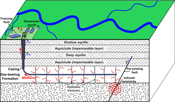
Hydraulic fracturing (a.k.a. “fracking”) recovery techniques for oil and natural gas are a controversial business. The practice—in which a mix of water, sand and chemicals is injected deep into bedrock at high pressure to create fractures, allowing gas and oil to flow upward—was developed in the late 1990s and has become more and more common across the United States over the past few years, opening up geologic areas such as the Bakken Shale in North Dakota and the Marcellus Shale in Pennsylvania, New York and West Virginia to dramatic increases in gas production.

On the one hand, proponents argue that hydraulic fracturing increases the amount of energy that can be economically produced in the United States, making oil and gas cheaper and reducing our dependency on foreign imports. Opponents, though, note that fracking causes dangerous chemicals to leach into groundwater, releases known carcinogens into the air and increases our contribution to climate change.

Alongside these observed problems, though, a different sort of worry has emerged: the idea that hydraulic fracturing can trigger an earthquake. Scientists have known for decades that injecting fluids into the earth could cause quakes, but we were uncertain just how much of an increase widespread fracking might cause. This past spring, USGS scientists decided that the recent dramatic increase in the number of small quakes in the United States is “almost certainly manmade,” but were unable to conclusively tie it to this particular activity.

Now, the evidence is starting to pile up. A study published today in the Proceedings of the National Academy of Sciences finds a correlation between dozens of small earthquakes in Texas’ Barnett Shale region—the site of intensive hydraulic fracturing activity—and the locations of injection wells used to dispose of the wastes of this process. ”You can’t prove that any one earthquake was caused by an injection well,” says Cliff Frohlich, the University of Texas geologist who conducted the study, “but it’s obvious that wells are enhancing the probability that earthquakes will occur.

To come to the finding, Frohlich analyzed two years’ worth of data from a network of extremely sensitive seismographs that was installed in the region in 2009. He discovered dozens of small earthquakes that had not been previously reported—and found that all 24 of the quakes for which he was able to establish an accurate epicenter occurred within two miles of an injection well.

One important distinction is that these wells were the disposal sites for waste fluids that had already used to fracture rock, rather than the original wells used to extract the gas. Although the actual gas extraction wells cause many microearthquakes by their very nature (they literally crack the bedrock to release gas and oil), these are far too small to be felt by humans or cause any damage. The fluid disposal wells, though, are more likely to cause earthquakes of significance, because they are sites of injection for a longer duration over time.

Image via Wikimedia Commons/Mike Norton
The waste fluids may trigger earthquakes by acting as lubricants in pre-existing faults deep underground, allowing masses of rock to slide past each other more easily and relieve built-up pressure. All of the wells that Frohlich found correlated with quakes were home to high rates of injection (more than 150,000 barrels of fluid per month). However, there were other wells in the area with similar rates of injection that did not correlate with increased seismic activity. ”It might be that an injection can only trigger an earthquake if injected fluids reach and relieve friction on a nearby fault that is already ready to slip,” explains Frohlich.

The good news is that all of these earthquakes were still relatively small, with magnitudes of less than 3.0 on the Richter scale, unlikely to cause any damage on the surface. Seismologists, though, are concerned that fluid injection could cause larger quakes if the fluid migrates into older, deeper rock formations beyond the local shale, which are home to larger fault lines. A number of earthquakes that occurred in Ohio last year, including one with a 4.0 magnitude, were linked to disposal of fracking fluids.

Frohlich notes that much more research is needed to help us understand exactly why some wells are more likely to cause earthquakes than others. For those already concerned about fracking, though, his new research adds another major concern to a growing list.

domingo, 5 de agosto de 2012

Meat the future

ORIGINAL: Meat The Future


Meat the future is a project that intends to inform people about todays unsustainable and inhumane meat industry. But also give hope for a change as there is a solution in sight, called In Vitro meat.

Please help us spread the word!

If you would like to get in touch with us, please send an email to contact@meatthefuture.org

This is a project by Afshin Moeini, Christian Poppius and Kim Brundin from Beckmans College of Design.

martes, 24 de julio de 2012

United Nations project to revive Zambia’s forest

ORIGINAL: Daily Mail-Zambia
By DOREEN NAWA
July 19, 2012

MONITORING forestry losses in Zambia and the effects that the loss has on the environment can be a challenge because of lack of technical know-how.

NURSERY for future forest
Following the effects that deforestation has on the environment in relation to climate change, the situation in Zambia is rather a hopeless case for the lack of expertise in monitoring and managing forestry countrywide.

Environmental advocates say that forests play a critical role in mitigating climate change through the confiscation and storage of carbon in woody perennial biomass and soils.

Unfortunately, deforestation and forest degradation account for approximately 18 percent of annual global carbon dioxide emissions.

But all hope is not lost following the recently held training organised by the forestry department in the Ministry of Lands, Natural Resources and Environmental Protection under the United Nations collaborative programme on Reducing Emissions from Deforestation and forest Degradation (UN-REDD) project and the Food and Agriculture Organisation (FAO).

The training was meant to build capacity of stakeholders in greenhouse gas reporting as well as Monitoring, Reporting and Verification (MRV) system as support to the readiness process of forestry management in Zambia.

The training is critical to the sustainability and successful management of out forests in the country. By the way addressing the driver of deforestation is the cheaper way of addressing climate change,” director in the forestry department, Anne Masinja says.

According to Mrs Masinja, management of the forest has been a challenge following massive deforestation due to charcoal burning, unsustainable agricultural and unsustainable land use practices.
It is a pity that most of the people do not realise the harm they are causing to the environment due to careless cutting of trees. Loss of forests contributes as much as 30 percent of global greenhouse-gas emissions each year and this is very dangerous, we need to do something to stop this,” Mrs Masinja says.

Zambia has approximately 50 million hectares of forest, with an estimated deforestation rate of 250,000 to 300,000 hectares per year.

Zambia is faced with a number of challenges in reducing deforestation and forest degradation caused by various factors like energy requirement, unsustainable agricultural and unsustainable land use practices, timber and non-timber forest products extraction, mining and infrastructure development,” Mrs Masinja said.

Statistics show that between 1990 and 2010, Zambia lost an average of 166,600 hectares or 0.32 per cent per year of its forest mainly due to deforestation resulting from charcoal burning (energy requirements), unsustainable agricultural and land use practices such as mining and infrastructure development, and timber and non-timber forest products extraction.

Indiscriminate charcoal burning is fast destroying Zambia's forest cover. 
Indiscriminate charcoal burning is fast destroying Zambia's forest cover.

With global concern growing over deforestation, loss of carbon stored in forests and the role of forests in climate change, the spotlight has been turned on forest monitoring in a bid to safeguard forests and monitor emissions from deforestation.

In another recent effort in the monitoring and managing of the forest in the country was the handover of Geographical Information System (GIS) equipment to the department.

As part of the mission to monitor the remaining forest in the country, the participants were also trained to undertake a countrywide remote sensing survey of forests.

The survey will substantially improve knowledge on land use including deforestation, reforestation and natural expansion of forests.

It is hoped that the training and the handover of new GIS equipment, the forestry department and other stakeholders will strengthen the capacity of all provinces countrywide to monitor their own forests.

The need to improve national forest monitoring is overwhelming as the demand for information has never been greater even in the face of some challenges. National policy processes are striving to address cross-cutting issues such as poverty alleviation and food security related to forests,Julian Fox, Food and Agriculture Organization UN-REDD MRV facilitator for Zambia says.

FAO supports Zambia’s efforts to close the knowledge gap through field inventories and forest monitoring systems.

Deforestation continues at an alarming rate of about 13 million hectares annually at the global level. By combining remote sensing technology with field data collection, we improve the quality of both methods. This provides more accurate information on forest trends and new information on the drivers of deforestation and forest degradation,” Dr Fox says during his facilitation at the training.

About REDD
In 2005, a group of developing countries launched a new initiative that put forest conversation on the international agenda known as REDD.

While REDD is a new name, the activities to ensure reduced deforestation and forest degradation are well known to Zambians and these include conservation agriculture, community based natural resources management, joint forest management, sustainable energy projects (solar, improved stoves), enhancing policy and legislative frameworks.

REDD therefore calls for an integrated approach to forest management, the main reason for the training.
Land use change and especially deforestation contributes about 20 percent of greenhouse gas emissions.

Under the UN-REDD programme, Zambia is expected to come up with a policy statement to regulate forest and the country is said to have been making steady progress towards the UN-REDD collaborative programme.

The UN-REDD programme assists developing countries to prepare and implement national REDD strategies and mechanisms towards addressing climate change.

Zambia is one of the nine countries piloting the UN-REDD programme that helps countries to get ready for the REDD mechanism in addressing climate change.

The other eight countries include Tanzania, Democratic Republic of Congo, Bolivia, Viet Nam, Paraguay, New Papua Guinea, Panama and Indonesia.

And during the training, UN-REDD national co-ordinator Deuteronomy Kasaro said, “UN-REDD Programme is not a development project as it has been understood by some, but instead it is a process of consultations, strategic planning, creative thinking and seeking realistic solutions to reduce deforestation and forest degradation and make REDD work for Zambia.

In recognition of the role REDD can plan in reducing emissions and facilitating sustainable socio-economic development, the Government of the Republic of Zambia is presently assessing the opportunities that can be potentially delivered through REDD,” Mr Kasaro added.

While the goal of reversing deforestation and achieving sustainable development is clear, the path to reach it can only be paved by Zambia and Zambians themselves.

The growing interest among stakeholders towards REDD is felt not only through the high participation in the training while developing its UN-REDD national programme document, but also through the numerous questions and discussions with people and organisations willing to support the efforts to protect the forests in Zambia.

The questions range from a request to provide seedlings for a tree-planting at a local school for guidance on designing sub-national forest monitoring systems that are aligned to the national measurement, reporting and verification (MRV) framework.

Reducing emissions from deforestation and forest degradation or REDD also mitigates climate change by changing the amount of carbon dioxide emissions to the atmosphere from the existing forest carbon stocks.

Carbon is becoming a commodity which can be managed and traded as a household and community income stream. The involvement in measurement and monitoring of forest carbon by local people can empower them as co-managers of areas under REDD projects.

At international level it has been recognised that addressing the drivers of deforestation is one of the cheaper ways to mitigate against the impact of climate change. Hence the ability of stakeholders to assess and monitor landuse changes aimed at addressing the drivers of deforestation being vital.
It is believed that understanding drivers of deforestation and sources of greenhouse gas emissions in landuse, landuse change and forestry will enhance capacity to effectively monitor the source and potential changes.

In fact poverty plays a major role in deforestation. Just like in any other developing country, in Zambia most people in rural areas have no the options for survival like jobs or reliable businesses and rural people end up in the forest for survival.

The high poverty level costs the entire world through the loss of forests (deforestation). Without finding a lasting solution to poverty, saving the forests providing for these people, rainforests cannot be saved.

Misunderstandings
While there are uncertainties in both the international REDD framework and the national arrangements, it is essential not to let these uncertainties discourage the actors who feel the urgency of acting now to stop deforestation.

To quell misunderstandings about the programme and to reassure the multitude of actors involved, a significant part of the programme funding has been allocated to building the institutional arrangements and stakeholder engagement processes that provide a platform for discussing the issues and finding the answers that work best the Zambian context.

viernes, 29 de junio de 2012

Mysterious African 'Fairy Circles' Stump Scientists

ORIGINAL: Live Science
Stephanie Pappas, LiveScience Senior Writer
27 June 2012

Mysterious bare spots called "fairy circles" dotting the sandy desert grasslands of Nambia have long stumped scientists who have no idea how the strange patterns form. CREDIT: Mike and Ann Scott of the NamibRand Nature Reserve
In the sandy desert grasslands of Namibia in southern Africa, mysterious bare spots known as "fairy circles" will form and then disappear years later for no reason anyone can determine. A new look at these strange patterns doesn't solve the wistful mystery but at least reveals that the largest of the circles can linger for a lifetime.

Small fairy circles stick around an average of 24 years, while larger ones can exist as long as 75 years, according to research detailed today (June 27) in the journal PLoS ONE. Still, the study sheds little light on why the circles form , persist and then vanish into the landscape after decades.

"The why question is very difficult," said study researcher Walter Tschinkel, a biologist at Florida State University. "There are a number of hypotheses on the table, and the evidence for none of them is convincing." [ See Photos of Fairy Circles ]

Circles of life (and death)

Tschinkel grew interested in fairy circles during a 2005 safari to NamibRand Nature Reserve in southwest Namibia, in the Namib Desert. It was his first experience with the round clearings, tens of thousands of which expose the red sandy soil in the area. A short time after the circles form, a tall ring of grass grows around the border, highlighting the bare area.
The smallest are about 6.5 feet (2 meters) in diameter, while the largest can be almost 40 feet (12 m) across. Eventually, plants move back in, re-colonizing the circles and leaving only slightly indented "ghost circles" behind. CREDIT: Mike and Ann Scott of the Namib Rand Nature Reserve
Few researchers have studied fairy circles, in part because of their remoteness, 111 miles (180 km) from the nearest village. It's an arid landscape where springbok, ostriches, leopards and other large animals roam, Tschinkel told LiveScience.

"It's like dying and going to heaven if you like remote, beautiful desert places," he said.

At first glance, Tschinkel assumed the circles marked underground nests of harvester termites. But digs have shown no evidence of termite nests under fairy circles. Other explanations, such as differences in soil nutrients or the death of seedlings by toxic vapors from the ground, have likewise failed to hold up to study.

In fact, little was known even about the life cycle of the circles, Tschinkel said. With the help of the nature reserve's staff, satellite images and aerial photos, he set out to change that. By comparing satellite images from 2004 and 2008, he found that circles are quite stable, popping up at nearly their full size, or growing quickly to full size once they get started. The smallest are about 6.5 feet (2 meters) in diameter, while the largest can be almost 40 feet (12 m) across. Winds scour the bare areas of soil, turning them into slight depressions. Eventually plants move back in, recolonizing the circles and leaving only slightly indented "ghost circles" behind. [ Gallery: Aerial Photos Reveal Mysterious Stone Structures ]

Assuming that the overall number of fairy circles on the landscape is fairly steady, Tschinkel used the satellite photos to look at how quickly the circles go from birth to maturity to revegetation. That yielded rough estimates of the circles' life spans. Most probably exist for 30 to 60 years, Tschinkel said.

Persisting mystery

Tschinkel was able to bolster these estimates thanks to a fundraising effort by the Namib Rand Nature Reserve, which sells sponsorships to fairy circles. The sponsored circles are marked with a ceramic plate, and their GPS coordinates are recorded. Over the 10 years of the sponsorship program, staff members have checked on the status of the sold circles. Their data yielded similar age ranges for fairy circles as the satellite images did, Tschinkel found.

He also determined that the circles form only on sandy soil with minimal stoniness, and that they don't form on shifting dunes or alluvial fans, where sands are deposited by water.

Some of Tschinkel's experiments are still ongoing, but so far, they've generated no leads on the circles' origins. Tschinkel suspects the circles are the product of some form of natural self-organization by plants.

"There are some mathematical models that are based on the idea that plants can withdraw resources toward themselves, which has a positive feedback on plant growth where they're located, but it has a negative effect on plants at a greater distance," he said.

Computer models based on this math can generate landscapes that look a bit like the fairy circle fields of Namibia, he said. But even if that hypothesis is on the right track, it doesn't explain how the plants are creating this pattern, not when hoarding soil nutrients and some other possible factors have already been ruled out.

With few people studying the circles — and no funding for chasing down the mysteries of the landscape of southern Africa — Tschinkel said the fairy circles will likely remain an enigma.

"I'm not too worried that this mystery is going to be solved anytime soon," he said. And the persistence of the mystery makes it ever more intriguing.

"That's science, isn't it?" Tschinkel said. "If you knew the answer ahead of time, it wouldn't be much fun."

Follow Stephanie Pappas on Twitter @sipappas or LiveScience @livescience . We're also on Facebook & Google+ .


jueves, 21 de junio de 2012

Combatiendo la desertificación

ORIGINAL: UNCCD


The 2008 theme of the Day is Combating Land Degradation for Sustainable Agriculture. Country Parties, international and non-governmental organizations are invited to organize events to celebrate the World Day to Combat Desertification as an additional opportunity to increase awareness and participation in the implementation process.


miércoles, 6 de junio de 2012

Quebec pledges $2.7 billion to tackle climate change

ORIGINAL: Edmonton Journal
BY MONIQUE BEAUDIN, 
THE GAZETTE JUNE 3, 2012


MONTREAL - Quebec plans to spend $2.7 billion to tackle climate change by 2020.

In the new 2013-20 climate-change action plan, made public in Montreal on Sunday by Premier Jean Charest, Quebec will act on a variety of fronts to meet its goal of bringing greenhouse-gas emissions to 20 per cent below 1990 levels by 2020.

In 2009, Quebec’s greenhouse-gas emissions were 2.5 per cent below 1990 levels. In order to reach its 2020 goal, Quebec estimates it would have to cut emissions by 11.7 megatonnes by 2020. The plan announced Sunday, the first part of a two-phase plan, would cut about 6.1 megatonnes, the government said. The second phase of the plan will be announced between now and 2020.

Quebec plans to spend two-thirds of the money on transportation measures, such as improving public transit, carpooling, taxi-sharing and active transportation like walking and cycling.

The transportation sector creates nearly half of Quebec’s greenhouse-gas emissions.

Quebec plans to spend about $200 million helping companies improve their carbon footprint and energy efficiency, and another

$100 million on research into reducing greenhouse-gas emissions, developing climate-monitoring networks and adapting to climate change.

The government also will spend $94 million helping municipalities and communities cut greenhouse-gas emissions, adapt to climate change and practise sustainable land-use planning.

New funding for municipal climate programs will allow cities like Montreal to tackle the problems of heat-island effect and stormwater run-off, said Montreal executive-committee vice-chairman Alan DeSousa, who is in charge of sustainable development for the city.

Other measures announced Sunday include adopting new energy-efficiency standards for home appliances, encouraging the use of hybrid trucks and supporting the development of environmentally friendly neighbourhoods.

Funding for the plan will come from revenues from a new carbon market, the government said.

Municipalities welcomed the government’s announcement that it would invest in municipal climate programs, while the Société de Transport de Montréal said the plan confirms the importance of public transit in the fight against climate change.

But environmental groups said the government could have done much more.

While certain aspects of the plan are “interesting,” the government should be reducing its investments in new highways and road projects, said the groups Équiterre and the David Suzuki Foundation. The only way to reach the 2020 goal is for the province to make a major shift to public transit, the groups said.

The Federation of Quebec Municipalities, while welcoming the new funding for municipal climate programs, said it would have liked Quebec to invest in creating a market for the compost and biofuels created from organic waste, and to help smaller municipalities provide home composting bins to their residents to reduce the amount of garbage going to landfills, where decomposing organic waste produces methane gas, a greenhouse gas.


Twitter: @moniquebeaudin
© Copyright (c) The Montreal Gazette


jueves, 31 de mayo de 2012

Genes Culled from Desert Soils Suggest Potential Medical Resource

ORIGINAL: Science Daily


ScienceDaily (May 27, 2012) — Despite their ecologic similarity, soils from three geographically distinct areas of the American southwest harbor vastly different collections of small, biosynthetic genes, a finding that suggests the existence of a far greater diversity of potentially useful products than was previously supposed. The research is published in the May issue of Applied and Environmental Microbiology.

Natural compounds have been the sources of the majority of new drugs approved by the US Food and Drug Administration, and bacteria have been the biggest single source of these therapeutically relevant compounds. Most bacterially-derived antibiotic and anticancer agents were discovered by culturing bacteria from environmental samples, and then examining the metabolites they produce in laboratory fermentation studies. But the vast majority of bacterial species cannot be cultured, which suggested that the world might be awash in potentially useful, but unknown bacterial metabolites.

In this study, Sean Brady of the Howard Hughes Medical Institute, Rockefeller University, New York, NY, and colleagues extracted DNA from soils from the Sonoran Desert of Arizona, the Anza Borrego section of the Sonoran Desert of California, and the Great Basin Desert of Utah. They used this DNA to construct very large metagenomic DNA libraries, and screened these libraries for three of the most common classes of small molecule biosynthesis systems,
  • type I modular polyketides
  • type II iterative polyketides, and 
  • non-ribosomal peptides
says Brady.

The investigators used PCR to amplify collections of gene fragments from each of the three libraries and compared these to assess the similarities and differences between the collections of genes cloned from each environment, says Brady.

"Our work suggests that the genomes of environmental bacteria could encode many additional drug-like molecules, including compounds that might serve, among other things, as new antibiotics and anticancer agents," says Brady. "This is a small preliminary study that warrants additional investigations of more environments and more extensive sequence analysis, but it suggests that environmental bacteria have the potential to encode a large additional treasure trove of new medicines."


domingo, 8 de abril de 2012

TEDxTC - Jonathan Foley - The Other Inconvenient Truth

ORIGINAL: TED

Planteamiento del problema presentado por la agricultura actual:

La agricultura ocupa:
  • 40% de la superficie de la tierra, 16'000.000kms2 equivalentes al tamaño de América del Sur. 30'000.000kms2 en pastos. 
  • Usamos 2.800km3 de agua al año en irrigar cosechas o 400m3 por c/u de los 7.000 millones de habitantes de la tierra. (1km3 equivale a 1000 millones de m3)
  • el 70% del consumo de agua
  • es responsable por un 30% de las emisiones de gases de efecto invernadero (más que la producida por la generación de electricidad, la industria y los vehículos de toda clase). 
  • Dobla el flujo de Nitrógeno y Fósforo por causa de los fertilizantes empleados
  • Además causa una enorme pérdida de biodiversidad 
Para fines de siglo será necesario DOBLAR la producción agrícola  (somos 7 billones de personas hoy y seremos 9 billones en 2040) para suplir las necesidades alimenticias y energéticas de la población. ¿Cómo se va a lograr ésto?
No a costa de superficie terrestre sino con mayor rendimiento de los suelos utilizados.

Necesidades a considerar  en el uso de la tierra cultivable:
  • Producción de pastos y cosechas
  • Producción de bosques
  • Preservación de hábitats y biodiversidad
  • Regulación del flujo del agua
  • Regulación de la calidad del aguas
  • Captura de Carbono del aire
  • Regulación del clima y calidad del aire regionales
  • Mediación en enfermedades infecciosas

Jonathan Foley: Profesor

Jonathan Foley estudia sistemas ambientales complejos y sus efectos en la sociedad. Sus modelos computacionales han demostrado que la agricultura está teniendo profundo impacto en nuestro planeta.

¿Por qué le debe escuchar?:
El Dr. Jonathan Foley se centra en la compleja relación entre los sistemas mundiales de medio ambiente y de la civilización humana, usando modelo computacionales para analizar los cambios en el uso del suelo, los ecosistemas y los recursos de todo el mundo. Después de 15 años en la Universidad de Wisconsin, Foley es actualmente profesor y presidente McKnight de la Junta en el Departamento de Ecología y director del Instituto del Medio Ambiente de la Universidad de Minnesota.

miércoles, 21 de marzo de 2012

Un futuro difícil y seco para el planeta. Abril 22 día Mundial del Agua

ORIGINAL: The Independent Sarah Morrison
Lunes 12 de marzo 2012


Cuando los organismos mundiales se reunieron la semana del 12 al 17 de Marzo en Marsella para discutir los suministros de agua, Sarah Morrison reporta sobre cómo su desperdicio va a crear un mundo sediento para el 2050. 


El mundo está perdiendo agua a una escala colosal, de acuerdo con las Naciones Unidas. Más del 80 por ciento del agua utilizada en la Tierra ni se recoge ni es tratada - equivale a que el planeta deje los grifos y los desagües abiertos.

Esta y otras realidades igualmente preocupantes se presentaron la semana pasada a alrededor de 35.000 personas de 180 países en el Foro Mundial del Agua, un encuentro que se celebra cada tres años, en el cual se escucharon informes más preocupantes todavía en el estado de los ríos del mundo, lagos y acuíferos .

La demanda de agua se espera que aumente en un 55 por ciento durante los próximos cuatro décadas, según un nuevo estudio que fue presentado en el foro en Francia. El Marco para el Desafío de Reforma del Agua, de la Organización para la Cooperación y el Desarrollo Económicos (OCDE), señala que la rápida urbanización, el cambio climático y la economía mundial están poniendo alterar las crecientes presiones sobre los recursos hídricos. Con el tiempo, en alrededor de 40 años, más del 40 por ciento de la población mundial - 3.9 mil millones de personas - es probable que se vivan en las zonas de los ríos a merced del severo "estrés de agua". La ONU advierte que esto también se dejará sentir en algunas partes de Europa, y afectará a 44 millones de personas en 2070.

Anthony Cox, director de un programa de correr el agua por la OCDE, dijo que el mundo está experimentando una "crisis" de agua. Y agregó: "Más gente en las ciudades tienen menos acceso al agua que en el año 1980 en los países en desarrollo, sobre todo, hay un enorme costo económico y humano debido a ésto.". Desde 1900, más de 11 millones de personas han muerto a causa de la sequía, según la ONU, y más de 2 mil millones se han visto afectados por ella - más que cualquier otro riesgo físico.

La OCDE aboga por "una reforma urgente" de la gestión del agua y sugiere el uso de instrumentos económicos, como impuestos, aranceles y transferencias, para fomentar una mayor "eficiencia del agua".

Olcay Unver, Coordinador Mundial de las Naciones Unidas de la Evaluación del Agua, dijo que sería un "cambio de juego" si el mundo pudiera hacer frente a los retos ambientales sin necesidad de llegar a desperdiciar el agua,  y usaralas tecnologías, como los biocombustibles. "El agua es la base de todos los aspectos del desarrollo", dijo. "Es el único medio a través del cual todas las crisis puede ser abordado en forma conjunta. Debe ser visto como un elemento explícito en un marco de toma de decisiones."

El Sr. Unver es el autor principal de un informe publicado por la ONU que advierte que el crecimiento sin precedentes en la demanda de agua está amenazando los objetivos mundiales de desarrollo y va a exacerbar las desigualdades entre países, sectores y regiones. La Gestión del Agua en virtud de programas de incertidumbre y riesgo que, mientras que el 86 por ciento de la población en las regiones en desarrollo se espera que tengan un mejor acceso al agua potable para el año 2015, todavía hay cerca de 1 mil millones de personas carecen de ese acceso y, en las ciudades, las cifras son creciente.

La gestión del agua ya no puede ser vista como un problema local, dijo el señor Unver, tiene que ser tratado como un problema mundial. "El agua no es sólo la que bebemos, con la que lavamos, o lo que usamos para regar, sino que también está contenida en los productos que consumimos, comemos y usamos", dijo. "Esto nos da una perspectiva totalmente diferente del agua - que está sujeta a las políticas comerciales, y una nación o una corporación, puede tener un impacto en la escasez de agua en otro lugar."

Su advertencia se acumula en el análisis de la Real Academia de Ingeniería, el cual encontró que el Reino Unido y otros países desarrollados dependen en gran medida de la importación deagua "virtual" u oculta de las zonas propensas a las sequías y la escasez. En un informe de 2010, la Academia estimaba que dos tercios de toda el agua que necesita Gran Bretaña viene incorporado en los alimentos importados, los productos industriales y la ropa como el algodón. En 2008, un estudio publicado por el grupo ecologista WWF encontró que alrededor del 60 por ciento de la huella hídrica de Gran Bretaña impacta fuera del Reino Unido.

Ashok Chapagain, asesor senior de agua de WWF, dijo: "La escasez de agua afecta al menos a 2,7 millones de personas en 201 cuencas de los ríos por lo menos durante un mes al año el comercio internacional y la globalización de la cadena de suministro ... hacen de la escasez de agua un problema mundial.. "

Pero su demanda no se espera que disminuya. Cada vez más, las fuentes subterráneas de agua se han aprovechado para responder a la creciente demanda y, de conformidad con lo que el informe de lo  que la ONU llamó una "revolución silenciosa", este proceso se ha triplicado en los últimos 50 años. La adquisición de tierras transnacional, donde los países adquirir tierras fuera de su jurisdicción para obtener el acceso al agua, ha aumentado de 20 millones de hectáreas en 2009 a más de 70m en la actualidad.

Para ilustrar las soluciones políticas, técnica y financiera a los problemas hídricos del mundo, un Pueblo de Soluciones de 400 metros cuadrados se construirán en el interior del Foro del Agua de este año, que albergará una escuela, la biblioteca, el ayuntamiento, la fábrica y el banco. Los diferentes mecanismos de financiación y las tecnologías se explicarán.

Sin embargo, el foro, organizado por el gobierno francés, el Consejo Mundial del Agua y la Ciudad de Marsella, donde se lleva a cabo, ha sido criticado por ser más que una "tertulia". "Van a tener los grandes debates allí, pero no es donde se producirá el cambio", dijo Daniel Yeo, asesor principal de políticas de WaterAid para la seguridad del agua. "La situación real es que el agua sucia mata a más niños en el África subsahariana que la tuberculosis, la malaria y el sida juntos tenemos la tecnología para cambiar esta situación,. Lo que necesitamos es la voluntad política y la capacidad interna para entregarlo en los países en desarrollo. "

domingo, 11 de marzo de 2012

Los misterios de Fukushima

ORIGINAL: RT
12 de marzo 2012 | 06:25

Foto: Google Earth
Cuando hace un año, Japón se vio golpeado por un terremoto enorme de magnitud 9 seguido de un devastador tsunami que destruyó gran parte de Fukushima en la Isla Honshu, pocas personas comprendieron en aquel momento que serían las explosiones de los reactores de la planta nuclear Dai-Ichi las que generarían verdadera preocupación global. No solo desde el punto de vista de la seguridad nuclear, sino también por haber indicios de serias derivaciones políticas de este accidente, que ha demostrado ser mucho más grave que el evento de Chernóbyl en la ex-URSS en 1986.

Ya se han registrado preocupantes niveles de radioactividad en distintas partes del Japón y en la región del Pacífico, a medida que la contaminación fue arrastrada por los vientos, el agua y penetró en suelos y napas de agua, afectando sembrados, localidades, alimentos, instalaciones industriales y sus productos de exportación. Las explosiones de la planta Dai-Ichi también descargaron toneladas de desechos radioactivos en el Océano. Luego de un año, aún prevalecen muchos puntos oscuros sobre este evento catastrófico
Foto: Google Earth

En un interesante artículo publicado en la revista estadounidense-japonesa 'Hyphen', titulado “El mundo se encuentra impotente ante la contaminación de Fukushima”, el ex-director general del 'The Japan Times Weekly' y consultor en materia de lucha contra los efectos de la radiación, Yoichi Shimatsu, explica que puede que detrás del desastre de Fukushima se oculten más cosas de lo que aparecen a primera vista.    

Por ejemplo, existen rumores que señalan un potencial encubrimiento al máximo nivel decidido a minimizar la verdadera gravedad de este desastre nuclear. En consonancia con los intereses del lobby favorable a la energía nuclear, la información y el debate sobre este caso han quedado mayormente paralizados. Sin embargo, la opinión pública japonesa y mundial manifiesta creciente preocupación ante la falta de información clara y oportuna, tanto de las autoridades japonesas como de entes internacionales acerca del verdadero alcance de la contaminación.

Fukushima es un ejemplo de masivo ocultamiento por los medios de difusión occidentales en torno al verdadero peligro para la población, especialmente en la zona del Pacífico Norte desde Japón hasta Norteamérica.

En su artículo, Shimatsu señala que “no se está debatiendo con precisión sobre los peligros a la salud pública mundial dado que los gobiernos se encontrarían imposibilitados ante la monstruosidad nuclear que han creado. Luego de asegurarle al mundo durante décadas que la energía nuclear no es peligrosa, ahora queda demostrado que las cosas no son así, tras los efectos inesperados luego del colapso de los reactores en marzo 2011, abriéndose así una caja de Pandora que supera la imaginación de los científicos de las grandes corporaciones y los ingenieros burócratas, quienes ahora solo reaccionan con un silencio confuso”.

Luego, señala que los desafíos incluyen “una creciente amenaza a la salud reproductiva humana consecuencia de la ingestión de isótopos radioactivos provenientes de alimentos, agua potable y la respiración, que resultarán en abortos masivos y una declinación poblacional en Japón, tendencia que podrá extenderse a nivel mundial”, y que incluiría “mutaciones de patógenos contagiosos tales como la gripe aviaria, dados los desordenes genéticos tanto en microorganismos como en especies portadoras que ocasionará, incluyendo en  animales domésticos y vida silvestre”.

Pero existen otros aspectos preocupantes provenientes de la catástrofe de Fukushima que estarían siendo silenciados. Por ejemplo, el entonces primer ministro japonés Naoto Kan jamás aclaró por qué razón impuso un hermetismo total en torno a las primeras reuniones de su gabinete de emergencia, ni porqué su gobierno ordenó al operador de Dai-Ichi, la Tokyo Electric Power Company (TEPCO) que no abandonara el reactor No.1 luego de las explosiones del 15 de marzo, que se supo fue para evitar reacciones en cadena, según indica una investigación realizada por la entidad Rebuild Japan Initiative Foundation.

Este tipo de secretismo de máximo nivel junto con el contenido peligrosamente elevado detectado en distintos lugares del isótopo Cesio-137 (y 134) como en la ciudad de Osaka a 600 kilómetros de distancia (niveles 100 veces mayores que los normales, según un informe del Instituto de Salud Pública de Osaka del 19 de mayo de 2011), señalarían que el reactor Fukushima No. 1 podría haber sido utilizado para reprocesar uranio de calidad militar.

De demostrarse la veracidad de esto, ello conformaría una clara violación por Japón del tratado de No Proliferación de Armas Nucleares, en cuyo caso se esperaría que la Agencia Internacional de Energía Atómica (AIEA) a cargo del japonés Yukiya Amano y los gobiernos de EE. UU. y Reino Unido, al menos investigarían y procurarían levantar el velo sobre estos puntos oscuros. Pero, no: pareciera que todos están demasiado ocupados en inventar pruebas sobre la inexistente amenaza nuclear iraní. La AIEA, en su postura muy favorable a los intereses de EE. UU., Reino Unido y sus aliados, apenas si ha prestado alguna atención a lo que ocurre en Fukushima.

Según fuentes anónimas dentro de la agencia de no proliferación de EE. UU., se sospecha de la existencia de uranio altamente radioactivo que correspondería a ojivas nucleares norteamericanas desmanteladas y almacenadas en piletones de combustible gastado en Fukushima, pudieron haberse encendido luego que el terremoto dejara fuera de servicio las bombas de agua.   La serie de detonaciones que ocurrió no permitió que los equipos de reparación pudieran acceder a los controles del núcleo del reactor, que eventualmente se derritió perforando sus cámaras de contención, lo que hizo que tomara contacto directo con el suelo debajo del mismo. Buena parte de ese material nuclear enriquecido provendría de los arsenales militares de EE. UU., según un acuerdo secreto del año 2006 entre los gobiernos de George W. Bush y Shinzo Abe de Japón.

Los operarios de emergencia en la planta también informaron que recientemente se le habría reinstalado al supuestamente vacio reactor No. 4 una nueva cobertura de acero por su constructor General Electric (GE). encontrándose totalmente cargado con nuevas varillas de combustible. A su vez, los dos reactores adicionales habrían sido utilizados para operaciones clandestinas de enriquecimiento de uranio previo a su extracción.

Según Shimatsu, las empresas Hitachi Electric y Honeywell estarían en sociedad para desarrollar un sistema de laser-plasma para extraer plutonio y uranio de alta pureza. Estas corporaciones, junto con la GE (EE. UU.), GEC (Reino Unido), y otras, operan en red y conforman un lobby favorable a la industria de la energía nuclear, cuyos principales nódulos a lo largo de las últimas seis décadas han incluido al Ministerio de Economía, Comercio e Industria del Japón –un verdadero estado dentro del Estado japonés– al Partido Demócrata Liberal y a los departamentos de Estado y de Defensa de EE. UU. Todos, a su vez, coordinados a través de altos directivos y funcionarios de gobierno que son miembros de la poderosa Comisión Trilateral de Rockefeller/Rothschild.

De comprobarse la existencia de algún tipo de colaboración encubierta en programas de armas nucleares entre Washington y Tokio, ello conformaría una violación abierta de tratados internacionales y del Tratado Estadounidense-Japonés de Seguridad por el cual Japón permite bases militares estadounidenses en su territorio a cambio de protección norteamericana bajo su “paraguas nuclear”.

En tal caso estaríamos ante otro caso de doble discurso por parte de las potencias occidentales en materia nuclear, lo que no habrá de sorprender toda vez que se tenga en cuenta el apoyo secreto que desde hace décadas brinda EE. UU. al desarrollo del programa militar nuclear de Israel, tolerando incluso que dicho Estado no firme el Tratado de No Proliferación de Armas Nucleares.

¿Qué misterios se ocultan detrás de Fukushima? ¿Qué secretos inconfesables ocultan GE, GEC, TEPCO, Hitachi, Honeywell y los gobiernos japonés y estadounidense en este tema? 

Pareciera que se necesita unir los puntos más apartados e improbables para formarnos una imagen correcta de esta realidad…

Adrian Salbuchi para RT en Español

Adrian Salbuchi es analista político, autor, conferencista y comentarista en radio y TV de Argentina. www.asalbuchi.com.ar

domingo, 27 de noviembre de 2011

Siete Ciudades que usted debe visitar antes de que se hundan

ORIGINAL: WorldGeography

Muchos de nosotros damos por sentado la idea de que todas nuestras ciudades queridas  estarán vigentes los siglos por venir. Sin embargo, las ciudades de todo el mundo parecen estar compitiendo por el título de "La Próxima Atlántida". Los cimientos tambaleantes y los mares que las invaden están planteando una amenaza significativa para algunas de las ciudades más grandes y más apreciadas del mundo. A la hora de planificar sus próximas vacaciones, tenga en cuenta que algunos de los destinos favoritos del mundo tiene poco tiempo con ellas. Aquí están las siete ciudades principales que se están preparando para dar el paso.


7. Bangkok, Tailandia

Fuente de la foto

La capital de Tailandia se está hundiendo - y rápido. Sin embargo, a diferencia de otras ciudades en nuestra lista, unas fundaciones de mala calidad no son necesariamente las culpables. Recostada sobre el río Chao Phraya - que desemboca en la bahía de Bangkok a unos 30 kilómetros al sur del centro de la ciudad - este asentamiento colosal es más probable que se inunde que de hundirse. Los expertos dicen que este destino atractivo - junto con las decenas de hermosos templos que se encuentran aquí - pueden estar bajo el agua en tan sólo siete años.

Mercado Flotante de Bangkok. fuente de la foto

Según el científico de  Tailandia Dr. Ajong Chumsai na Ayudhya, el destino de Bangkok se puede explicar mejor por el calentamiento globalAsia News Network informa que "Ajong dijo que los humanos eran los principales responsables de estos desastres, ya que están empleando los recursos naturales, la tala de los bosques y se mantiene emitiendo gases de efecto invernadero sin tener en cuenta para el futuro". Ajong también dice que los cambios en el clima global de la Tierra darán lugar a más inundaciones graves en el Golfo de Tailandia, que tendrá efectos muy negativos en la parte sur del país. Con menos de una década de sobra, el tiempo podría estar acabándose para un viaje a Tailandia, uno de los destinos turísticos más populares.


6. Nueva York, Nueva York, EE.UU.

Si usted nunca ha visto la Estatua de la Libertad o han sido deslumbrados por las luces de Times Square, ahora es el momento. Al igual que su compañera Tailandia, la  ciudad de Estados Unidos más densamente poblada está condenada a sufrir los efectos del calentamiento global Sentado en la desembocadura del río Hudson, donde desemboca en el Océano Atlántico, esta jungla de asfalto pronto estará en un riesgo mucho mayor de daños causados ​​por los niveles crecientes del mar y la imposición de las tormentas tropicales. Y a diferencia de aquellos que están en un barril de Halloween, esta Gran Manzana no flota.
Fuente de la foto
Science Daily informa de que el nivel del mar en el área de Nueva York se espera que aumente el doble de rápido del nivel del mar en todo el mundo, lo que significa que la ciudad dará el paso antes que el resto de los Estados Unidos. Sin embargo, Science Daily dice que la inundación es sólo uno de los síntomas de Nueva York van a sufrir: "La inmersión de las tierras bajas, la erosión de las playas, la conversión de humedales para abrir el agua y el aumento de la salinidad de los estuarios, pueden afectar los ecosistemas y el daño de desarrollo existentes costeras ". No sólo el Empire City se transforma en una piscina, sino que poco a poco se acerca hacia el mar.