Mostrando entradas con la etiqueta Satélite. Mostrar todas las entradas

lunes, 3 de junio de 2013

ARKYD: A Space Telescope for Everyone

ORIGINAL: Kickstarter


The first publicly accessible space telescope! Take amazing photos of space or have your photo displayed above the Earth.


06-02-2013 – Let’s spread the word!
Big Thank YOU to everyone who has pledged their support to make a publicly-accessible ARKYD space telescope a reality! Many of you have asked how you can help support ARKYD. We've put together a supporter's resource to help reach more people. You'll find translations of the various materials prepared by our community and learn how you can connect with other supporters.


Since the formation of Planetary Resources, our primary goal has been to build technology enabling us to prospect and mine asteroids. We've spent the last year making great leaps in the development of these technologies. These advancements have presented us with the opportunity to engage in another passion of our team:

to make space exploration accessible to everyone.

Space has always been something that most people only dream about. Very few ever get the chance to experience space — to feel that overwhelming sense of awe described by astronauts. Our challenge and vision is this: how can we make
that a reality?

Introducing: The ARKYD — [ahrk-kid]

The ARKYD is a technologically advanced, orbiting space telescope that will be controlled by YOU, the crowd, through your pledges and community involvement! You can even direct your telescope time to non-profit science centers and universities for use in your communities!

Just think about the true impact of this endeavor for a moment. Together we can provide access to technology that costs tens of millions of dollars into the hands of students, scientists and a new generation of explorers, who will use it in ways we can’t even fathom yet!

At Planetary Resources, our primary focus is mining asteroids, and we’re pushing the boundaries of what is possible by vertically integrating and applying innovations from consumer-based industries. It’s our goal to reduce the cost of space observatories many times over, allowing anyone to access them for their own use. We want to empower the crowd to solve the big problems of our time — and this is the first step to making that a reality.


The first publicly accessible space telescope! Take amazing photos of space or have your photo displayed above the Earth.

Our primary mission is to develop low-cost robotic spacecraft to explore and mine resource-rich asteroids within our reach. The first step to making this possible is the launching a fleet of ARKYD spacecraft to identify asteroids that are ripe for further exploration. This same capability has numerous other potential applications in education and research. The goals that we want to achieve with this Kickstarter mission are four-fold:

To give students access to space capabilities — Whether studying planets in a 5th grade class or writing a graduate thesis, students of all ages will have the ability to direct the telescope and explore what interests them! We’re planning some exciting new educational opportunities just for K-12 educational programs.

To support important research and discovery — There are thousands of institutions and researchers in need for greater access to in-orbit space observatories. The ARKYD will provide a new, low-cost resource to help observe distant galaxies, search for alien planets, and monitor the skies for potentially dangerous asteroids. Researchers at MIT, the University of Washington, and across the globe have shown interest in using the ARKYD to further their important research.

To build excitement about space and all of its potential — The ARKYD is designed to be a fun and interactive experience that is accessible to anyone. This kind of direct access to a satellite is unprecedented. Our backers will be the first people in history to control a public space telescope!

To give YOU a say — What makes this mission unique is that we’re putting control of the telescope in YOUR hands. You’ll get the opportunity to help decide which science centers and museums are the beneficiaries of ARKYD telescope time, what photos to take, and more. We’re putting YOU in control! By pledging toward this mission, you’ll receive access to our website and mobile apps allowing you to follow along with the progress of the satellite, sneak peaks at photos and videos, and get voting access to make your voice heard in the future direction of the satellite!


The engineering and development of the telescope itself is being covered by Planetary Resources, and we're investing millions of dollars in research and development to develop the ARKYD with advanced capabilities like photographing deep space and searching for asteroids. However, a publicly accessible satellite is very different from those that we intend to launch for the purposes of locating asteroids. The engineering and technological needs for doing each of those jobs are quite different.

Here's where we need YOUR help: The proceeds from this campaign will go to several different areas:
  1. To actually launch the satellite into space. 
  2. To support the spacecraft over its lifetime — including manpower to facilitate the photos, "selfies", monitoring the spacecraft and training the staff at the chosen science center that will take over control. 
  3. To create an easy-to-use Control Interface that will allow ANYONE to access and control the satellite. 
  4. To fund the creation of an incredible, interactive educational experience that can be used by schools anywhere, to enable students to experience space in a way that's never been possible.


domingo, 7 de octubre de 2012

Space X/Dragon Heads to ISS

ORIGINAL: NASA

The historic launch of the first commercial cargo ship to the International Space Station marks the return of America's capability to independently resupply the orbiting laboratory.

viernes, 28 de septiembre de 2012

Business Impact: El empresario que vende premios

POR ANTONIO REGALADO
TRADUCIDO POR LÍA MOYA (OPINNO)
VIERNES, 28 DE SEPTIEMBRE DE 2012


Peter Diamandis dirige grandes y llamativos concursos tecnológicos. Afirma que crean innovación que no se daría de otra manera.

Peter Diamandis es un médico y emprendedor aeroespacial que conoce la psicología humana. Por eso inventó la Fundación X Prize, para conseguir crear, mediante concursos, lo que él denomina “avances radicales” en beneficio de la humanidad. El primer premio Ansari X Prize –un premio de 10 millones de dólares (unos 77 millones de euros) otorgado en 2004 al primer vuelo espacial tripulado privado- generó tanta publicidad que Diamandis afirma que solo la cobertura de prensa que recibió valía 120 millones de dólares (unos 92 millones de euros).


Un cheque inmenso: Peter Diamandis (extremo izquierdo) entrega un cheque de 5 millones de dólares a los ganadores del X Prize Progressive Insurance para vehículos eficientes en 2010. 
Fuente: Cortesía de la Fundación X PRIZE | foto de David Freers

Desde entonces Diamandis y su fundación han recaudado muchos más millones para poner en marcha concursos para encontrar mejores formas de limpiar vertidos de petróleo o producir coches que consigan hacer 43 kilómetros por litro de gasolina. También han establecido el mayor premio tecnológico de la historia: un premio de 30 millones de dólares (unos 23 millones de euros) para la primera organización privada capaz de colocar un robot en la luna. Diamandis habló con Technology Review sobre lo que quiere lograr.

Technology Review: ¿Qué sabe de la naturaleza humana que le condujo al negocio de los premios?

Diamandis: Genéticamente, los humanos están programados para competir. Lo hacemos para buscar pareja, en el deporte, en el trabajo. La competencia incentivada fuerza a la gente a adaptarse a una serie de limitaciones con un objetivo claro que los ayuda a resolver un problema. En vez de pensar creativamente, se trata de pensar concentradamente.

Porque si las personas se enfrentan a un problema sin restricciones, son vagas. Usan todos los recursos, tiempo y dinero que tienen disponibles. Van a lo seguro. A la gente no le gusta arriesgarse. Si limitas el problema, bien las condiciones de tiempo, bien el dinero, la mayoría dirán que no se puede hacer y se retirarán. Pero quienes dicen “Vale, voy a intentarlo” tienen que pensar muy bien cómo hacerlo. Eso los obliga a enfrentarse al problema de una forma completamente distinta. Esta situación normalmente sería muy arriesgada. Pero en un concurso, en el que si ganas, te llevas el gran bote, la gente está dispuesta a asumir riesgos mayores. Si se cuenta con una base amplia de concursantes, quienes lo logren habrán, por pura definición, hecho algo nuevo.

Technology Review: Si los X Prizes fueran la única forma de financiar la tecnología, ¿qué clase de tecnología acabaríamos teniendo?

Diamandis: Mi respuesta es que se trata de crear un mundo de abundancia. Se trata de crear un avance que permitirá no una vida de lujo, sino una vida posible para siete mil millones de personas, que tengan sus necesidades básicas cubiertas en términos de agua, comida, energía y sanidad. Se trata de resolver los grandes retos del mundo. Hay problemas que tienen mil millones de personas que se podrían resolver en un periodo de 10 años si hubiera gente centrada en conseguirlo.

Technology Review: La cantidad de dinero necesaria para competir en un X Prize es bastante importante. ¿Este concurso es solo para los más ricos?

Diamandis: Todos los equipos usan el premio, el escaparate del premio, su fama , para incentivar las inversiones. Antes de que existiera el Ansari X Prize, una conversación que se repetía era: “¿Financiaría mi cohete espacial?”. Y la mayor parte de la gente decía “¿Estás loco? Eso solo lo hace la NASA”. No había ningún tipo de validación externa. En nuestro concurso para buscar sistemas de limpiar vertidos petrolíferos, siete de los diez equipos clasificados eran equipos muy pequeños. Eran empresas familiares. Uno de ellos se había conocido en un estudio de tatuaje de Las Vegas, pero aún así duplicaron lo que los gigantes de la industria llevaban haciendo 20 años.

Technology Review: Dado lo rápido que se mueve la tecnología por sí misma, ¿por qué hacen falta premios siquiera?

Diamandis: Buena pregunta. Un motivo es acelerar el movimiento en determinado sentido. Y el segundo, usando el término acuñado por Clay Shirky, es que hay muchísima “plusvalía cognitiva” en el mundo. ¿Cómo se aprovecha eso para hacer algo constructivo y positivo? Tenemos el premio Qualcomm tricorder para una nueva generación de tricorders médicos [son los aparatos como los de Star Trek, capaces de analizar la salud de una persona sin tocar su cuerpo]. Los aparatos podrán estar disponibles dentro de cinco o diez años, pero los concursos sirven para establecer estándares de regulación, ayudan a atraer capital, ayudan a los emprendedores a centrarse en objetivos específicos. Hay millones de personas que se mueren en la actualidad que no se morirían si existiese este tipo de tecnología.

Technology Review: Qualcomm donó 20 millones de dólares (unos 15,4 millones de euros) a su fundación, pero solo la mitad es para los ganadores del concurso. La otra mitad va a la fundación. ¿No son unos gastos excesivos? 

Diamandis: Me frustra que la gente haga ese tipo de comparaciones. La gente que dice “¿Por qué unos gastos tan elevados?” no entienden lo que implica diseñar y lanzar un concurso, las relaciones públicas, las relaciones institucionales, el jurado, crear instalaciones para llevar a cabo el concurso y la validación de los resultados. Con Qualcomm haremos todo un ensayo clínico al final. Compararlo con una fundación que da becas y dice “Aquí tienes tu dinero, mándanos un informe anual”, es una tontería.

viernes, 31 de agosto de 2012

Arctic Sea Ice Hits New and Early Summer Low for Satellite Era

ORIGINAL: NYTimes
August 27, 2012

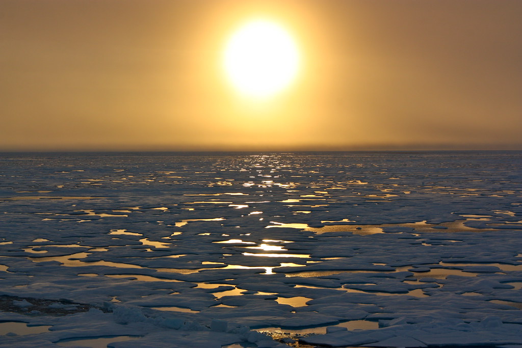
Sunsets started to tease the Arctic horizon as scientists on board the U.S. Coast Guard Cutter Healy headed south in the Chukchi Sea during the final days collecting ocean data for the 2011 ICESCAPE mission.  The ICESCAPE mission, or "Impacts of Climate on Ecosystems and Chemistry of the Arctic Pacific Environment," is a NASA shipborne investigation to study how changing conditions in the Arctic affect the ocean's chemistry and ecosystems. The bulk of the research took place in the Beaufort and Chukchi seas in summer 2010 and 2011. Credit: NASA/Kathryn Hansen

11:44 p.m. | Updates from several scientists below |
The planet is warming and the Arctic is warming the most, as long foreseen by scientists in a climate system pushed out of balance through the rapid buildup of heat-trapping greenhouse gases in the atmosphere. One result is greater loss of Arctic sea ice in the annual summer warmup.

Today, the National Snow and Ice Data Center announced that the annual summer retreat of Arctic Ocean sea ice had reached a new low for the 33-year satellite era of careful monitoring (1.58 million square miles, or 4.1 million square kilometers), and there is still another week or two of melting before the typical summer ice minimum occurs.

This quote in the release from Walt Meier of the ice center efficiently encapsulates the context:
"By itself it’s just a number, and occasionally records are going to get set. But in the context of what’s happened in the last several years and throughout the satellite record, it’s an indication that the Arctic sea ice cover is fundamentally changing."

The animated sea-ice imagery above — from one of two autonomous cameras set on ice near the North Pole each spring — gives a close-focus view of the slushy conditions that develop on the shifting ice when the summer sun is at its peak. (This is part of the annual North Pole Environmental Observatory project that I reported on in 2003; the cameras drift with the ice through the summer and are currently over the shoulder of Greenland. You can track their position here.)

Justin Gillis has more on this development over on the news side of The Times. This excerpt echoes the thinking of quite a few ice researchers I’ve interviewed over recent years:

“It’s hard even for people like me to believe, to see that climate change is actually doing what our worst fears dictated,” said Jennifer A. Francis, a Rutgers University scientist who studies the effect of sea ice on weather patterns. “It’s starting to give me chills, to tell you the truth.”

Still, there are many other veteran sea-ice scientists (this is not false balance) who note that the complexity of this system has consistently defied predictions in either direction (see this year’s Sea Ice Outlook forecasts to get the range of forecasts).

sábado, 28 de julio de 2012

'Grand Canyon' under Antarctica tied to ice loss, researchers report

ORIGINAL: NBC News
By Miguel Llanos, NBC News

Rob Bingham
The edge of the Ferrigno Ice Stream is seen from a plane. A valley below the stream as well as an offshore channel appear to be allowing relatively warmer sea water to eat away at the ice from below.

A newly discovered Antarctica valley buried by ice and as deep as the Grand Canyon could be contributing to rising sea levels, scientists reported Thursday.

The ancient topography is such that relatively warm sea water could be eating away at the ice edge -- and a question for future research is whether that process is happening elsewhere along Antarctica's coastal rift valleys. 

A few other ice-covered valleys have been found but the geology of this one, discoverer Rob Bingham told NBC News, shows that "the areas that are most vulnerable (to ice loss) coincide with areas of ancient rifting."

It seems the geological process over millions of years "preconfigures the topography to a shape that encourages ice loss," said Bingham, a glaciologist at Scotland's University of Aberdeen.

Reported in the peer-reviewed journal Nature, the find came about when Bingham was part of a British Antarctic Survey team looking at the Ferrigno Ice Stream, an area on the vulnerable West Antarctic Ice Sheet, to see why it was losing ice.

"It was in doing this that we discovered the ice in this region is underlain by a rift" a mile deep in places, Bingham said. Radar showed that "ice losses are concentrated over the rift," he added, allowing researchers to conclude that "the rift topography exacerbates the current ice losses."

Ice from the rift also carved a channel over millions of years that is now covered by coastal seas and appears to be allowing relatively warmer water to "flow back towards the Antarctic ice margin" and then melt it, Bingham said.

The melt causes the ice surface slope to steepen "and this in turn accelerates ice flow such that the ice surface drops over time. The presence of the rift valley facilitates this flow and is thus contributing to gradual depletion of the central ice cover."

Others scientists said the discovery would help better understand the dynamics of Antarctica.
Rob Bingham
This illustration shows the Ferrigno Ice Stream, outlined in black and just above a channel, seen in green, that appears to allow relatively warmer water to eat away at the ice margin.

"There could be more rifts like this and the study gives us ideas to test in other places," Tom Wagner, who manages NASA's ice research programs, told NBC News. Such rifts, he added, "could potentially cause very rapid ice flow."


The British Antarctic Survey agreed on the significance.

"The West Antarctic Ice Sheet is of great scientific interest and societal importance as it is losing ice faster than any other part of Antarctica with some glaciers shrinking by more than one meter (three feet) per year," it said in a statement coinciding with the study.

"Thinning ice in West Antarctica is currently contributing nearly 10 percent of global sea level rise," added BAS scientist David Vaughan. "It's important to understand this hot spot of change so we can make more accurate predictions for future sea level rise."

Study co-author Fausto Ferraccioli, a BAS scientist, told NBC News that satellite and aircraft surveys over the rift would help better explain the dynamics.

"We now need new airborne geophysical surveys both onshore and offshore," he said, in order to understand all facets of "this changing part of the West Antarctic Ice Sheet."

miércoles, 18 de julio de 2012

Drought Grips the United States

ORIGINAL: NASA
July 17, 2012

acquired June 25 - July 10, 2012
download large image (5 MB, JPEG, 3480x2234)


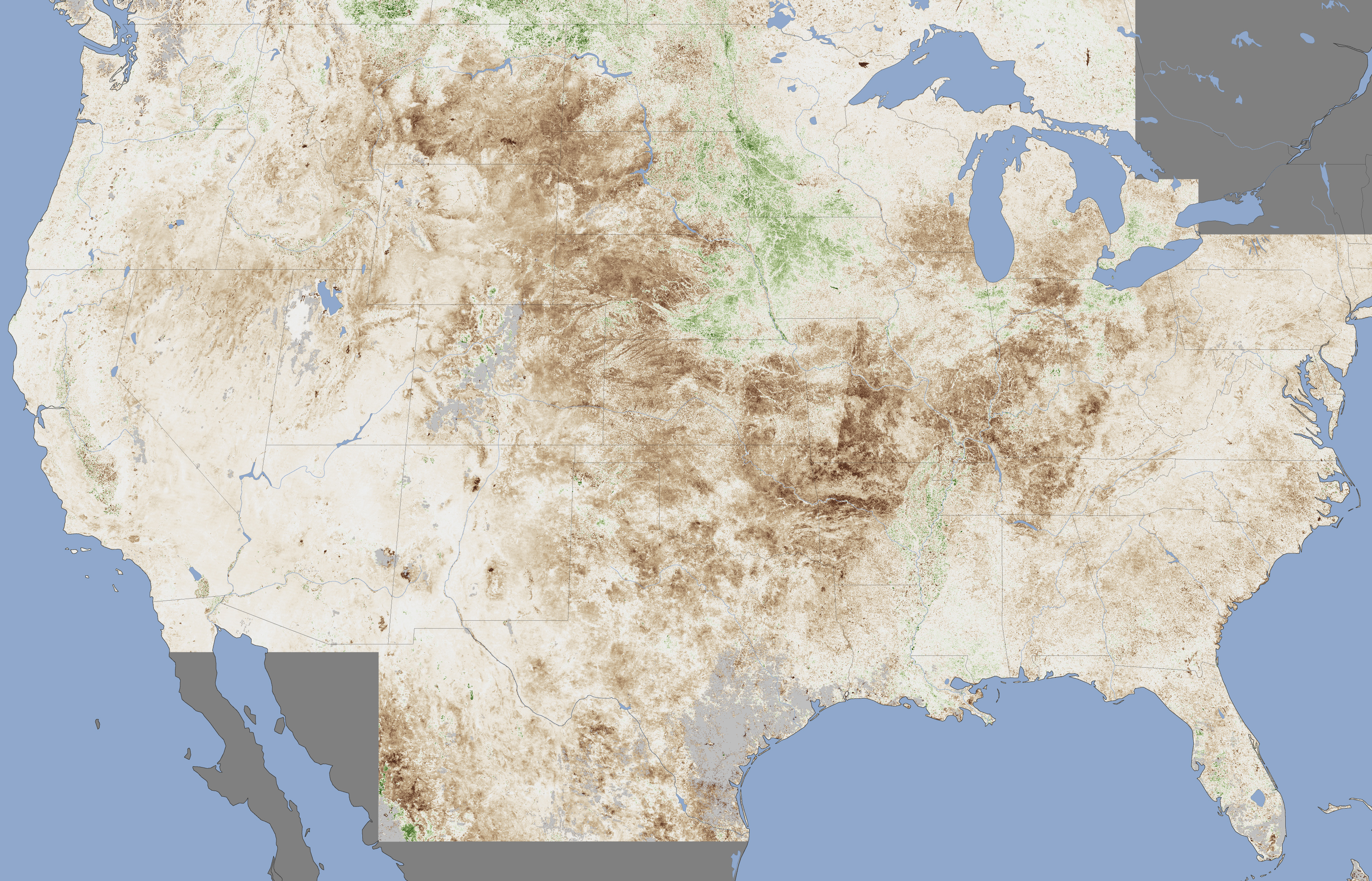
Farmers across the United States hoped for rain in July 2012 as a drought of historic proportions parched key commodity crops, including corn, soybeans, and wheat. On July 11, the United States Department of Agriculture announced that more than 1,000 counties in 26 states qualified as natural disaster areas—the largest total area ever declared a disaster zone by the agency.

The extent of the damage to crops is depicted in this vegetation anomaly map based on data from the Moderate Resolution Imaging Spectroradiometer (MODIS) on NASA’s Terra satellite. The map contrasts plant health in the central United States between June 25 and July 10, 2012, against the average conditions between 2002 and 2012. Brown areas show where plant growth was less vigorous than normal; cream colors depict normal levels of growth; and green indicates abnormally lush vegetation. Data was not available in the gray areas due to snow or cloud cover. The image is based on the Normalized Difference Vegetation Index (NDVI), a measure of how much plant leaves absorb visible light and reflect infrared light. Drought-stressed vegetation reflects more visible light and less infrared than healthy vegetation.

The most severe damage to crops appears to be centered on Missouri, Arkansas, Oklahoma, Texas, Kansas, Nebraska, and South Dakota. Crops in much of the upper Midwest—southern Wisconsin, Michigan, Indiana, southern Illinois, western Kentucky, and western Tennessee—also show signs of strain. States in the Mountain West that are in the midst of a busy wildfire seasonMontana, Wyoming, and Colorado—have also experienced marked declines in the health of vegetation. The drought has been less severe in Iowa, a key corn-growing state.

This drought, like all extreme weather events, has its direct cause in a complex set of atmospheric conditions that produce short-term weather. However, weather occurs within the broader context of climate, and there’s widespread agreement among scientists that the climate is changing due to human activity.

According to a recent IPCC report on extreme weather, there is “medium confidence” that droughts have grown longer and more severe in some parts of the world since 1950, particularly in southern Europe and West Africa. However, the trends appear to be the reverse for droughts in central North America and northwestern Australia. Overall, the scientists who prepared the IPCC report assert a medium level of confidence in their ability to attribute observed changes in drought patterns to human activity.

References
Atlantic Wire. (2012, July 12). U.S. Declares the Largest National Disaster Area Ever Due to Drought. Accessed July 16, 2012.
Climate Central. (2012, July 13). Midwest to Mid-Atlantic Bracing for Onslaught of Heat. Accessed July 16, 2012.
NASA Earth Observatory. (2010, June 3). Global Warming.
U.S. Drought Monitor. (2012, July). U.S. Drought Monitor: July 10 (pdf). Accessed July 16, 2012.

Further Reading
Farm Futures. (2012, July 14). Satellite Imagery Reveals Widespread Farm Crop Stress. Accessed July 16, 2012.
NOAA. (2012). State of the Climate National Overview: June. Accessed July 16, 2012.
Peterson, T. (2012, July). Explaining Extreme Events of 2011 from a Climate Perspective. Bulletin of the American Meteorological Society.

NASA Earth Observatory image by Jesse Allen, Earth Observatory,using data provided by Inbal Reshef, Global Agricultural Monitoring Project. Caption by Adam Voiland.Instrument: Terra - MODIS

sábado, 7 de julio de 2012

Huge 'Solar Tornado' Twists Across Sun's Surface in New Video

ORIGINAL: Space
SPACE.com Staff
Date: 29 March 2012 Time: 07:00 AM ET

NASA's Solar Dynamics Observatory spacecraft observed a "tornado" as wide as five Earths raging on the sun's surface on Sept. 25, 2011. This sequence of photos follows the tornado over 2 1/2 hours.

CREDIT: NASA/SDO/AIA/Aberystwyth University/Li/Morgan/Leonard
A NASA spacecraft has captured video of a massive solar "tornado" five times wider than the Earth twisting its way across the surface of the sun.

NASA's Solar Dynamics Observatory (SDO) looked on as the huge, swirling storm raged on Sept. 25, 2011, spinning solar gas at speeds up to 186,000 mph (300,000 kph), researchers said. Here on Earth, tornado wind speeds top out at around 300 mph (483 kph).

"This is perhaps the first time that such a huge solar tornado is filmed by an imager," Xing Li of Aberystwyth University in Wales, who analyzed the SDO footage, said in a statement. "Previously, much smaller solar tornadoes were found by the [NASA/European Space Agency] SOHO satellite. But they were not filmed."

Li and other researchers will present a movie of the tornado Thursday (March 29) at the 2012 National Astronomy Meeting in Manchester, the United Kingdom.


SDO's instruments saw gases as hot as 3.6 million degrees Fahrenheit (2 million degrees Celsius) rise from a dense solar structure called a prominence, then travel about 124,000 miles (200,000 kilometers) along a spiral path into the upper solar atmosphere, researchers said.

Unlike Earth's tornados, which are driven by wind, solar twisters are shaped by our star's powerful magnetic field. They often occur in concert with violent explosions of solar plasma known as coronal mass ejections, or CMEs. Some researchers think the tornados may help trigger CMEs, which can streak through space at several million miles per hour.

CMEs that hit Earth can wreak havoc on our planet, causing temporary disruptions in GPS signals, radio communications and power grids. They also typically supercharge the dazzling light shows near Earth's poles known as the northern and southern lights.

The $850 million SDO spacecraft, which launched in February 2010, is the first in a fleet of NASA efforts to study our sun. The probe's five-year mission is the cornerstone of a NASA science program called Living with a Star, which aims to help researchers better understand aspects of the sun-Earth system that affect our lives and society.

The sun is currently in an active period of its 11-year weather cycle. The current cycle is known as Solar Cycle 24 and will peak in 2013.

Follow SPACE.com for the latest in space science and exploration news on Twitter @Spacedotcom and on Facebook.

viernes, 29 de junio de 2012

Mysterious African 'Fairy Circles' Stump Scientists

ORIGINAL: Live Science
Stephanie Pappas, LiveScience Senior Writer
27 June 2012

Mysterious bare spots called "fairy circles" dotting the sandy desert grasslands of Nambia have long stumped scientists who have no idea how the strange patterns form. CREDIT: Mike and Ann Scott of the NamibRand Nature Reserve
In the sandy desert grasslands of Namibia in southern Africa, mysterious bare spots known as "fairy circles" will form and then disappear years later for no reason anyone can determine. A new look at these strange patterns doesn't solve the wistful mystery but at least reveals that the largest of the circles can linger for a lifetime.

Small fairy circles stick around an average of 24 years, while larger ones can exist as long as 75 years, according to research detailed today (June 27) in the journal PLoS ONE. Still, the study sheds little light on why the circles form , persist and then vanish into the landscape after decades.

"The why question is very difficult," said study researcher Walter Tschinkel, a biologist at Florida State University. "There are a number of hypotheses on the table, and the evidence for none of them is convincing." [ See Photos of Fairy Circles ]

Circles of life (and death)

Tschinkel grew interested in fairy circles during a 2005 safari to NamibRand Nature Reserve in southwest Namibia, in the Namib Desert. It was his first experience with the round clearings, tens of thousands of which expose the red sandy soil in the area. A short time after the circles form, a tall ring of grass grows around the border, highlighting the bare area.
The smallest are about 6.5 feet (2 meters) in diameter, while the largest can be almost 40 feet (12 m) across. Eventually, plants move back in, re-colonizing the circles and leaving only slightly indented "ghost circles" behind. CREDIT: Mike and Ann Scott of the Namib Rand Nature Reserve
Few researchers have studied fairy circles, in part because of their remoteness, 111 miles (180 km) from the nearest village. It's an arid landscape where springbok, ostriches, leopards and other large animals roam, Tschinkel told LiveScience.

"It's like dying and going to heaven if you like remote, beautiful desert places," he said.

At first glance, Tschinkel assumed the circles marked underground nests of harvester termites. But digs have shown no evidence of termite nests under fairy circles. Other explanations, such as differences in soil nutrients or the death of seedlings by toxic vapors from the ground, have likewise failed to hold up to study.

In fact, little was known even about the life cycle of the circles, Tschinkel said. With the help of the nature reserve's staff, satellite images and aerial photos, he set out to change that. By comparing satellite images from 2004 and 2008, he found that circles are quite stable, popping up at nearly their full size, or growing quickly to full size once they get started. The smallest are about 6.5 feet (2 meters) in diameter, while the largest can be almost 40 feet (12 m) across. Winds scour the bare areas of soil, turning them into slight depressions. Eventually plants move back in, recolonizing the circles and leaving only slightly indented "ghost circles" behind. [ Gallery: Aerial Photos Reveal Mysterious Stone Structures ]

Assuming that the overall number of fairy circles on the landscape is fairly steady, Tschinkel used the satellite photos to look at how quickly the circles go from birth to maturity to revegetation. That yielded rough estimates of the circles' life spans. Most probably exist for 30 to 60 years, Tschinkel said.

Persisting mystery

Tschinkel was able to bolster these estimates thanks to a fundraising effort by the Namib Rand Nature Reserve, which sells sponsorships to fairy circles. The sponsored circles are marked with a ceramic plate, and their GPS coordinates are recorded. Over the 10 years of the sponsorship program, staff members have checked on the status of the sold circles. Their data yielded similar age ranges for fairy circles as the satellite images did, Tschinkel found.

He also determined that the circles form only on sandy soil with minimal stoniness, and that they don't form on shifting dunes or alluvial fans, where sands are deposited by water.

Some of Tschinkel's experiments are still ongoing, but so far, they've generated no leads on the circles' origins. Tschinkel suspects the circles are the product of some form of natural self-organization by plants.

"There are some mathematical models that are based on the idea that plants can withdraw resources toward themselves, which has a positive feedback on plant growth where they're located, but it has a negative effect on plants at a greater distance," he said.

Computer models based on this math can generate landscapes that look a bit like the fairy circle fields of Namibia, he said. But even if that hypothesis is on the right track, it doesn't explain how the plants are creating this pattern, not when hoarding soil nutrients and some other possible factors have already been ruled out.

With few people studying the circles — and no funding for chasing down the mysteries of the landscape of southern Africa — Tschinkel said the fairy circles will likely remain an enigma.

"I'm not too worried that this mystery is going to be solved anytime soon," he said. And the persistence of the mystery makes it ever more intriguing.

"That's science, isn't it?" Tschinkel said. "If you knew the answer ahead of time, it wouldn't be much fun."

Follow Stephanie Pappas on Twitter @sipappas or LiveScience @livescience . We're also on Facebook & Google+ .


domingo, 24 de junio de 2012

Luizi Crater, Democratic Republic of the Congo


acquired June 2, 2012 download large image (4 MB, JPEG, 3000x3000)


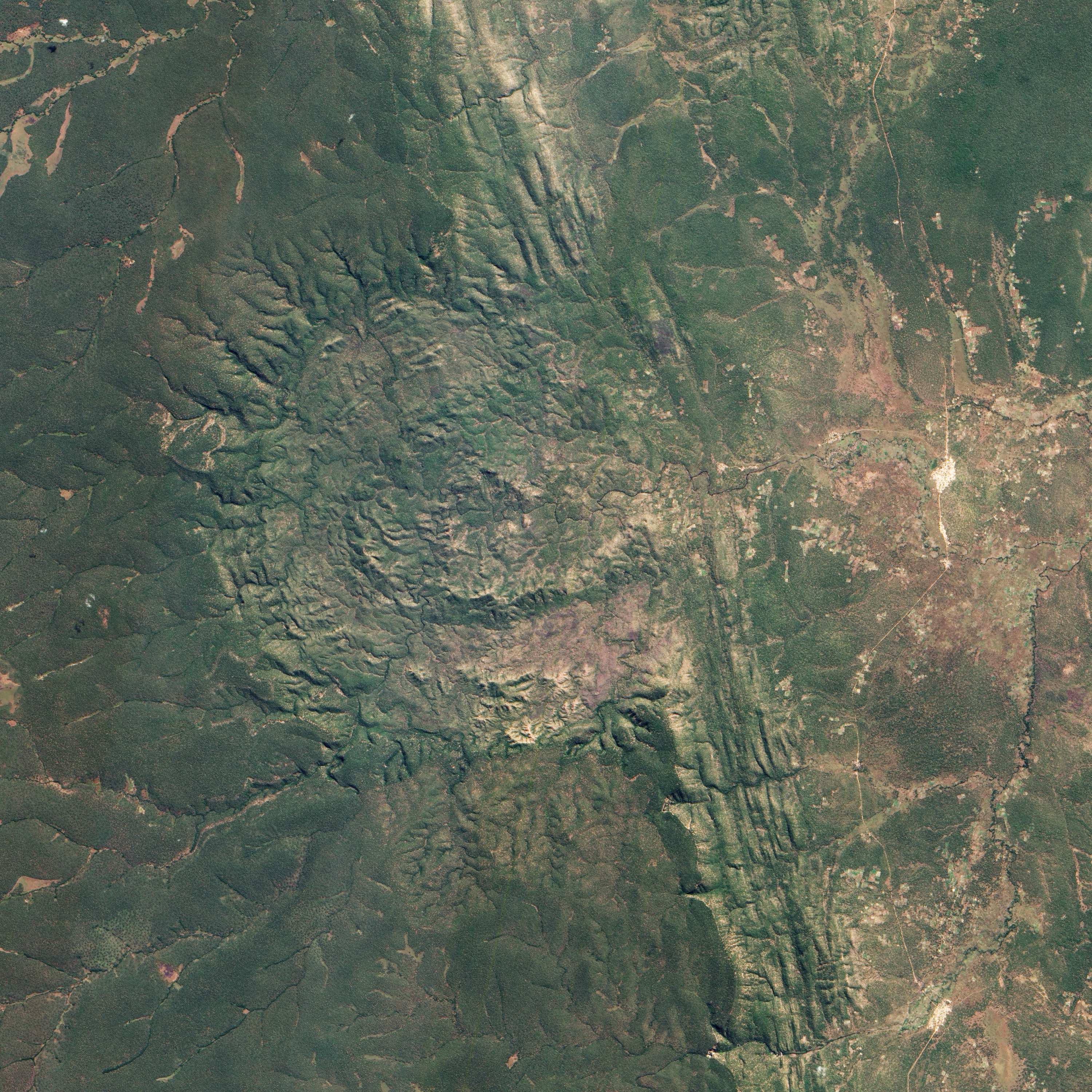
Impact craters can be tough to detect from the ground, especially if they are situated in remote locations and covered by vegetation. Both factors hampered understanding of the Luizi Structure, located in southeastern Congo. The crater is covered by grasses up to a meter (3 feet) high, and tucked away in central Africa.

The Advanced Land Imager (ALI) on NASA’s Earth Observing-1 (EO-1) satellite captured this natural-color image of Luizi on June 2, 2012. It is not perfectly round, but instead fills a semicircular basin where vegetation carpets the complicated topography.

A mention of Luizi made it into a geological report in 1919, but the feature remained unexplored for decades. Satellite imagery of the structure from the 1990s inspired an international team of geologists to look more closely. In 2011, they announced their findings.

Satellite imagery suggested that Luizi might be an impact crater, but volcanoes and even salt domes can form structures that look like impact craters, so the researchers had to go into the field. They found shatter cones, and microscopic analysis of rock samples collected from the site revealed shocked quartz grains. Both shatter cones and shocked quartz are considered strong evidence of meteorite impacts.

Impact craters can be simple or complex. While simple craters have uncomplicated bowl shapes, complex craters sport features that can be counterintuitive, such as inner rings and central peaks. Geologists have linked both crater types to the action of high-velocity impacts.

The researchers studying Luizi reported that the crater spans about 17 kilometers (11 miles) in diameter, with an intermittent ring about 5.2 kilometers (3.2 miles) across, and a smaller, center ring about 2 kilometers (1.2 miles) across. Around the perimeter of the crater, a rim rises approximately 300 to 350 meters (980 to 1,150 feet) above the interior. In short, Luizi is a well-preserved, moderately sized, complex crater.

Exactly when Luizi formed is hard to answer. The researchers estimate that nearby rocks are 575 million years old—more than 300 million years older than the first dinosaurs. But besides knowing that the impact can’t be older than the rock layers it disrupted, the geologists can’t yet say when the impact occurred. Whenever the meteorite arrived, it may have been moving as fast as 72,000 kilometers (45,000 miles) per hour.

Related Resources
Department of Earth Science and Engineering. (2012) The formation of complex craters. Imperial College, London. Accessed June 8, 2012.
Ferrière, L., Lubala, F.R.T., Osinski, G.R., Kaseti, P.K. (2011) The Luizi Structure (Democratic Republic of Congo) — First confirmed meteorite impact crater in Central Africa. 42nd Lunar and Planetary Science Conference, held March 7–11, 2011 at The Woodlands, Texas.
Ferrière, L., Osinski, G.R. (2011) The new Luizi Impact Structure (Democratic Republic of Congo) and implications for central peak and peak ring formation. 42nd Lunar and Planetary Science Conference, held March 7–11, 2011 at The Woodlands, Texas.
Jaggard, V. (2011, March 8) Huge impact crater found in remote Congo. Accessed June 8, 2012.

NASA Earth Observatory image by Jesse Allen and Robert Simmon, using Advanced Land Imager data from the NASA EO-1 team. Caption by Michon Scott.

martes, 19 de junio de 2012

Landsat Sets the Standard for Maps of World's Forests

ORIGINAL: Nasa

NASA's Earth-observing fleet of satellites provides a worldwide and unbiased view with standardized scientific data -- information crucial for tracking the health of the world's forests.

Countries like Brazil are using data from NASA satellites to track and measure their forests in advance of a United Nations effort to reduce climate change by providing "carbon credits" for protected land.

The concept is known as REDD+, which stands for Reducing Emissions from Deforestation and Forest Degradation. It includes monitoring forest degradation and efforts in conservation and sustainable management.

"REDD+ aims to make forests more valuable standing than they would be cut down, by creating a financial value for the carbon stored in trees," says Yemi Katerere, head of the United Nations' UN-REDD Programme Secretariat in Geneva, Switzerland. "It creates an incentive for developing countries to reduce carbon emissions by protecting, better managing and wisely using their forest resources, contributing to the global fight against climate change."

REDD+ will be a major topic of discussion during this week's Conference on Sustainable Development, known as Rio+20. Images and data acquired by Landsat satellites are increasingly becoming an accepted approach for anyone hoping to have a long-term view of the health of the world's forests.

"For example Brazil is using Landsat data from 1996 to 2005 to create a baseline for tracking future forest coverage," says Doug Morton, a NASA Landsat researcher at the NASA's Goddard Space Flight Center in Greenbelt, Md.


Tropical forest in Gabon, Africa. A NASA-led research team has used a variety of NASA satellite data to create the most precise map ever produced depicting the amount and location of carbon stored in Earth's tropical forests. Image credit: NASA/JPL-Caltech
NASA's Earth-observing fleet of satellites provides a worldwide and unbiased view with standardized scientific data -- information crucial for tracking the health of the world's forests. Many non-profits are using Landsat as a tool to identify and protect areas that are important for conservation. This video shows how the African Wildlife Foundation (AWF) has used Landsat in the Democratic Republic of the Congo to protect a wildlife corridor in the Maringa Lopori Wanga (MLW) region. (Credit: NASA's Goddard Space Flight Center) 


Consistently gathering data about our planet since 1972, the Landsat Program is a series of Earth observing satellite missions jointly managed by NASA and the U.S. Geological Survey (USGS).

Landsat's views of Earth are at a 30 by 30 meter (32.8 yard) resolution, about the size of a baseball diamond. "That's a pretty appropriate scale for doing country-wide estimates of forest change," Morton says. 

"All 40 years of Landsat data is also readily available from the USGS archive at no cost to the end user," Morton says. "That makes it one of the only sources of freely available satellite data with that time record and at that spatial resolution."

Forest monitoring activities in developing countries heavily depend on guaranteed continuity and freely and open access to satellite data, says Inge Jonckheere of the UN-REDD Programme at the Food and Agriculture Organization of the U.N. in Rome, Italy.

"It allows them to learn and apply existing image processing techniques in order to become autonomous in monitoring their own forest nationally," Jonckheere says. "Landsat data therefore has been crucial in our work so far, which was mainly focused on the assessment of deforestation."


NASA's Earth-observing fleet of satellites provides a worldwide and unbiased view with standardized scientific data -- information crucial for tracking the health of the world's forests. Countries like Brazil are using data from NASA satellites to track and measure their forests in advance of a United Nations effort to reduce climate change by providing "carbon credits" for protected land. This file photo shows a forest in Gabon, Africa.(Credit: NASA/JPL-Caltech) 

NASA and the U.S. Department of the Interior through the U.S. Geological Survey (USGS) jointly manage Landsat. The USGS preserves the archive of Landsat images and distributes all of the 40-years of Landsat data free over the Internet.

"The ability of governments or other organizations to freely access all this data is one of the factors that's led to a major drop in deforestation in the last ten years," Morton says. 

In the 1990s deforestation caused nearly 20 percent of the world's greenhouse gas emissions, but in 2009 Morton and his research team reported that that number went down to 12 percent. Morton concedes that part of that change is due to an increase in all emissions due to expanded fossil fuels use.

"But the rise of satellite-based monitoring is also a factor." Morton says. "It provided a way for governments and conservation groups to monitor new laws protecting forests and track changes made by major agricultural industries like palm oil plantations and soybean farmers.

"Data from satellites like Landsat have really changed the dynamic of deforestation in the last five to 10 years," he says. 

The data will continue to flow. Landsat 7 remains in operation 13 years after its launch. The next satellite in the Landsat series, which began in 1972 with the launch of Landsat 1, is scheduled to launch in January 2013 from Vandenberg Air Force Base in Lompoc, Ca. Known as the Landsat Data Continuity Mission (LDCM), it is the eighth satellite in the series and will extend the world's longest-running satellite program for global land observations. 

In addition to deforestation and forest recovery, scientists and governments are very interested in quantifying the amount of carbon that is stored as trees and vegetation in forests. 

"Tropical forests are extremely diverse in species and structure and this diversity impacts their carbon content, an important quantity for estimating emissions from deforestation and degradation" says Sassan Saatchi, a scientist at NASA's Jet Propulsion Laboratory in Pasadena, Calif. Saatchi and his team created the world's first map of tropical forest carbon storage using quantitative satellite data in 2011 and found that the Amazon stores most of the carbon in the tropics. 

Saatchi and his team use data from a suite of NASA satellites to map the forest carbon, including tree height from Geoscience Laser Altimeter System lidar on NASA's ICESat satellite, imagery from the Moderate Resolution Imaging Spectroradiometer (MODIS) instrument on NASA's Terra spacecraft, and active microwave data from NASA's Quick Scatterometer satellite (QuikSCAT) and the Shuttle Radar Topography Mission

The role of the REDD+ mechanism in achieving broader sustainable development goals will be further discussed at the U.N. Rio+20 conference, which takes place from June 20 to 22 in Rio de Janeiro, Brazil.

For more information about the Landsat Program, visit:


Aries Keck


martes, 12 de junio de 2012

Descubren un bosque bajo el Ártico


Es un bosque en medio del desierto helado”. Así lo describen, en un comunicado, los científicos que han descubierto, en una expedición de la NASA, que el Océano Ártico se está tiñendo de verde por la proliferación de plantas marinas microscópicas, que son esenciales para la vida en otros mares, pero que no habían sobrevivido hasta ahora en un ecosistema tan frío.

El calentamiento global está, según el trabajo publicado en ‘Science’ detrás de un fenómeno que hasta ahora no se había detectado en toda su amplitud.


La expedición ICESCAPE (siglas de Impactos del Clima en los Ecosistemas y la Química del Ártico) exploró las aguas de los mares de Beaufort y Chukchi, en Alaska, a bordo de un rompehielos estadounidense. “Hemos observado una masiva expansión del fitoplancton entre 800 centímetros y 1,3 metros en la capa helada del primer año en el mar Chukchi”, aseguran los autores.


Esa capa se extiende en más de 100 kilómetros, un fenómeno que no había sido observado hasta ahora. Los cambios en el Ártico ya habían sido detectados por imágenes de satélite de la NASA. La expedición tenía como objetivo confirmar los datos, en un lugar de difícil acceso desde tierra.

Hasta ahora se pensaba que estas plantas que tiñen de verde el agua y son la base de la cadena alimenticia marina, sólo crecían después de que el hielo del mar se retiraba, lo que ocurre en verano. El problema, dice el biólogo Sam Laney, del Woods Hole Oceanographic Institution, está en que, igual que un aguacero hace florecer el desierto, la acumulación de agua de deshielo en cortos periodos de tiempo en el Ártico tienen importantes efectos sobre el ecosistema.


Según sus análisis, al adelgazarse el hielo, la luz solar llega a las aguas que hay bajo la capa helada sobre el mar, lo que permite que la planta se desarrolle. “Si alguien me hubiera preguntado si veríamos flores bajo el hielo, les habría dicho que no era posible”, reconoce Kevin Arrigo, de la Universidad de Stanford y líder de la expedición. “Ha sido una completa sorpresa”, ha asegurado.


El fitoplancton, además, tuvo un crecimiento extremadamente activo, llegando a doblar su cantidad en un solo día, cuando las flores, en aguas abiertas, tardan dos o tres. Es más, los investigadores estiman que estas tasas pueden llegar a multiplicar por 10 las tasas de crecimiento de las plantas en aguas abiertas.

Como el fitoplancton, a su vez, consume grandes cantidades de dióxido de carbono, los científicos tendrán que evaluar, más adelante, cuánto CO2 está entrando en el Océano Ártico si resulta que estas plantas llegan a ser comunes bajo el hielo. “En este momento no sabemos si estas floraciones acaban de empezar a producirse o si es que no las hemos observado antes”, señala Arrigo, quien cree que si el hielo sigue adelgazando, al final se convertirá en un bosque sobre el mar.

Fuente: Diario El Mundo, Agencias

viernes, 1 de junio de 2012

Dragon's Back on This Week @NASA

ORIGINAL: NASA

The first commercial spacecraft to journey to the International Space Station returns safely to Earth. Also, new milestones for other commercial crew/cargo spacecraft; John Glenn awarded Presidential Medal of Freedom at White House; and more!

lunes, 30 de abril de 2012

¿Cómo lograr que los pescadores dejen de pescar en exceso?

ORIGINAL: TheEconomist
25 de febrero de 2012

De todos los muchos problemas del mar, la sobrepesca debe ser el más corregible. 
Así es como se puede hacer...

Foto: PA para The Economist
ACIDIFICACIÓN, calentamiento global, la destrucción de los arrecifes de coral: los mayores problemas que enfrenta el mar son tan amplios, profundos y aparentemente intratables como los propios océanos. Mientras el mundo no pare en reducir sus emisiones de gases de efecto invernadero, causa del calentamiento global detrás de estos problemas, ellos van a crecer. En comparación, la sobrepesca, la otra gran maldición, debería ser más fácil de corregir, sobre todo en las aguas costeras, donde la mayoría de la pesca se produce. Y sin embargo, continúa, año tras año.

Los pescadores tienen toda la razón para hacer algo. Muchas pesqueras van a toda velocidad hacia el colapso, las poblaciones de peces de gran tamaño se han reducido hasta en un 90%. Cuando las reservas están sobreexplotadas, que producen una captura menor. El costo de la mala gestión, en la pérdida de producción económica, es enorme: unos 50 millones de dólares al año, según el Banco Mundial.

Una razón por la cual el saqueo sigue es que el conocimiento de las poblaciones de peces es pobre, sobre todo en los países en desarrollo. Un nuevo intento de estadística en la estimación de los bancos restantes (ver artículo), de la Universidad de California en Santa Bárbara, por lo tanto, es bienvenida, incluso si eso no son verdad sus conclusiones, que las acciones son aún más devastadoras por lo que se pensaba. El estudio encontró que la pesca mejor entendida es más propensa a ser estable y sólida. Otra razón para la sobrepesca es la nueva tecnología (desarrollada, con acierto suficiente, para los campos de batalla), lo que hace más fácil de detectar bancos de arena. Como los barcos de gran tamaño y de refrigeración se han extendido, las flotas pesqueras han cubierto grandes distancias y arrasan con grandes capturas. Dado que la tecnología permite a los pescadores de peces operar con menos esfuerzo, explica lo rápido que las existencias se están agotando.

Los pescadores en general, comprender los riesgos de la sobrepesca. Sin embargo, todavía se ignoran las cuotas, si las hubiere. Esto es a menudo porque tienen una visión a corto plazo del activo- y que prefieren sacar provecho ahora e invertir el dinero en otra cosa. Y está, invariablemente, agravado por una sensación genralizada de despojo de bien comunes de que si no lo hacen su pillaje, otros lo harán.

En la mayoría de las pesqueras, los pescadores deberían ganar más dinero por preservar sus recursos para el largo plazo, y debe ser posible para incentivarlos a hacerlo. La mejor manera es darles derecho a una parte de los peces bien definida a largo plazo. En las pesquerías industriales reguladas, como en Islandia, Nueva Zelanda y Estados Unidos, esto ha tomado la forma de una participación negociables e individual de una cuota de pesca. Los países en desarrollo, donde la aplicación de la ley es débil, parece que les va mejor cuando un grupo tiene derechos sobre una extensión de agua se da a una flota de una cooperativa o un pueblo. El principio es el mismo: los pescadores que se sienten como propietarios son más propensos a comportarse como administradores responsables. El estudio estadístico reciente confirma que la pesca basada en derechos es generalmente más benigna.

El derecho material

Sin embargo, sólo unos pocos cientos de miles de flotas pesqueras en los océanos se comportan de esta manera, sobre todo porque estos sistemas son difíciles de establecer acertartadamente. Limitar el acceso a un recurso común crea perdedores, y por lo tanto la discordia. Las diferencias culturales afectan las tasas de éxito, no todos son tan respetuosos de la ley, como los islandeses. Casi en todas partes se necesita tiempo para convencer a los pescadores, los últimos cazadores-recolectores, a cambiar sus hábitos. Pero,  a pesar de que puede ser plagado de alertas, el enfoque basado en los derechos es el mejor disponible.

En los países ricos, las imágenes de satélite cada vez van a ayudar, haciendo el seguimiento más barato y mejor. En muchos de los pobres, la adopción a este método está en hacer que sea más fácil de formar organizaciones locales. Otra idea prometedora es la de incorporar la pesca basada en derechos, con zonas de prohibición de captura. Estos salvaguardaría las poblaciones de cría y son más fáciles de controlar que las capturas individuales. Cuando las poblaciones se empiecen a recuperar, como resultado de estas reformas, los pescadores estarán más propensos a ver las cuotas determinadas científicamente como en su propio beneficio. Al final, puede ser la única esperanza.