Mostrando entradas con la etiqueta Cráter. Mostrar todas las entradas

jueves, 5 de julio de 2012

Big Picture on Mars: NASA Rover Snaps Amazing Red Planet View

ORIGINAL: Space
by SPACE.com Staff
Date: 05 July 2012 Time: 04:00 PM ET

817 component images taken between Dec. 21, 2011, and May 8, 2012, taken by Mars Rover Opportunity combine in this image. Image released July 5, 2012. CREDIT: NASA/JPL-Caltech/Cornell/Arizona State Univ.
A long-lived NASA rover on Mars has beamed home a stunning panoramic view of the Red Planet, a spectacular panorama that a space agency description billed as the "next best thing to being there."

The new Martian panorama was snapped by NASA's Mars rover Opportunity, a six-wheeled robot that has spent more than eight years exploring the Red Planet. The image shows a full-circle view of Mars near a spot called "Greeley Haven," where Opportunity hunkered down during its last Martian winter.

"The view provides rich geologic context for the detailed chemical and mineral work that the team did at Greeley Haven over the rover's fifth Martian winter, as well as a spectacularly detailed view of the largest impact crater that we've driven to yet with either rover over the course of the mission," said Jim Bell of Arizona State University in Tempe, the lead scientists for Opportunity's Pancam imaging system, in a statement today (July 5).

Opportunity's new Mars panorama is actually a mosaic of 817 different images combined like a giant puzzle to make one huge image. It shows a stark landscape broken only by the Opportunity rover's own tracks and the robot's solar array.

While there are varying shades of red (and even some blue) in the Mars panorama, the image is actually a false-color view. Its colors were added artificially to "enhance the differences between materials in the scene," NASA officials explained in an image description. [More Mars Photos by Opportunity Rover]

Opportunity created the Mars panorama between Dec. 21, 2011, and May 8, 2012, while it was stationed at Greeley Haven, an outcrop of rock located on the rim of the giant Endeavour crater that has been the rover's main object of study since August 2011.

Rover mission managers named the outcrop as a tribute to Mars scientist Ronald Greeley (1939-2011), who served as a mission team member and taught planetary science at Arizona State University.

"Ron Greeley was a valued colleague and friend, and this scene, with its beautiful wind-blown drifts and dunes, captures much of what Ron loved about Mars," said Steve Squyres of Cornell University, Ithaca, N.Y., principal investigator for Opportunity and Spirit.

NASA launched Opportunity and its sister rover Spirit toward Mars on a mission that was originally slated to last 90 days. The two rovers far outlasted their warranties, with Spirit exploring its Gusev Crater landing site until getting stuck in deep Martian sand. NASA declared Spirit's mission over in May 2011.

Opportunity, meanwhile, keeps on trucking across the Martian surface.

On Monday (July 2), Opportunity logged its 3,000th Martian day, which mission scientists call "sols." The rover has driven a total distance of 21.4 miles (34.4 km) since landing on Mars, according to mission managers.

Follow SPACE.com on Twitter @Spacedotcom. We're also on Facebook & Google+.

sábado, 30 de junio de 2012

Discovery: Earth's Oldest Crater Is Largest Too

ORIGINAL: Space
Douglas Main, OurAmazingPlanet Staff Writer
Date: 29 June 2012 Time: 04:42 PM ET

An artistic interpretation of how a large meteorite impact might have looked. The crater formed in modern-day Greenland may be the oldest and largest yet discovered on Earth. CREDIT: Carsten Egestal Thuesen, GEUS 
A study of Greenland's rocks may have turned up something unexpected: the oldest and largest meteorite crater ever found on Earth.

Researchers think the crater was formed 3 billion years ago, making it the oldest ever found, said Danish researcher Adam Garde. The impact crater currently measures about 62 miles (100 kilometers) from one side to another. But before it eroded, it was likely more than 310 miles (500 km) wide, which would make it the biggest on Earth, Garde told OurAmazingPlanet.

The team has calculated it was caused by a meteorite 19 miles (30 km) wide, which, if it hit Earth today, would wipe out all higher life.

Mystery feature

In the 3 billion years since impact, the land has been eroded down to about 16 miles (25 km) below the original surface. But the effects of the intense shock wave and heat penetrated deep into the Earth, and remain visible today, said Garde, a researcher at the Geological Survey of Denmark and Greenland. [ Meteor Mania: How Well Do You Know 'Shooting Stars'? ]

Garde had been conducting research on Greenland's geology and noticed several strange features that didn't make sense. One day in September 2009, he came up with the extreme explanation of an impact from a meteorite. His team collected samples over the years and published the results in the July issue of the journal Earth and Planetary Science Letters. He's now "100 percent positive" it's a crater, for several reasons, he said.

For one, he found widespread crushed rocks in a circular shape that seemed to be caused by the shock waves of a massive impact.
Second, there are deposits of a melted mineral called K-feldspar (or potassium-feldspar) that could have been liquefied only at extremely high heat, like that caused by an meteorite's crash-landing .
There's also widespread evidence of weathering by hot water, which he thinks was caused by the ocean rushing into the crater after it struck the area. The area may have been covered by a shallow ocean at the time, but even if it wasn't, it doesn't matter, Garde said. "The crater from a meteorite that big would have caused the sea to rush in," he said.

Mining for minerals

The black circle on map shows the location of the meteorite impact near the town of Maniitsoq in Greenland. CREDIT: Geological Survey of Denmark and Greenland
John Spray, a meteorite expert at the University of New Brunswick, who wasn't involved in the research, said he thinks it's probably a meteor crater, but points out that it hasn't been proved, and may not be for some time. "It's very interesting and it's good science," he said. "But we don't really know how to recognize very old impact craters, because they are typically so highly modified."

That's because Earth is alive and constantly changing due processes such as erosion, precipitation and plate tectonics. At one time Earth likely had as many craters as the moon, which is essentially geologically dead. But these have mostly been wiped away, destroyed by erosion and the like.

Only around 180 impact craters have ever been discovered on Earth, and nearly one-third of them contain significant minerals deposits such as precious metals. The Canadian mining company, North American Nickel, is exploring the region where the potentially newfound crater is for nickel and other mineral deposits, company geologist John Roozendaal said. They are conducting airborne surveys and will soon do more mapping, small-scale sampling and drilling to see if they can find an area that could be economical to mine.

These impacts are of interest to mining companies not because of the large meteorites themselves — they typically vaporize — but because of the effect upon the Earth's surface. The impact heats rocks so much that metals can melt and then collect toward the bottom of the crater. Craters can also be important sources of oil and gas; the crushed, permeable rocks can act like a sponge, absorbing hydrocarbons.

Before this discovery, the oldest crater was thought to be the Vredefort crater in South Africa, estimated to be 2 billion years old. At 186 miles (300 km) wide, it's also the largest crater that remains visible. Scientists expect that there were many more craters formed around 3-4 billion years ago when Earth lacked a protective atmosphere.

Garde said the most interesting thing about the experience was finding an alternate explanation for something outside of his training. "I had a problem I couldn't solve in a region I knew very well," he said. "A meteor impact was the idea that made everything fall into place — It's not something I was looking for."

This article was provided by OurAmazingPlanet , a sister site of SPACE.com. Reach Douglas Main at dmain@techmedianetwork.com . Follow him on Twitter @Douglas_Main . Follow OurAmazingPlanet on Twitter @OAPlanet . We're also on Facebook and Google+ .


domingo, 24 de junio de 2012

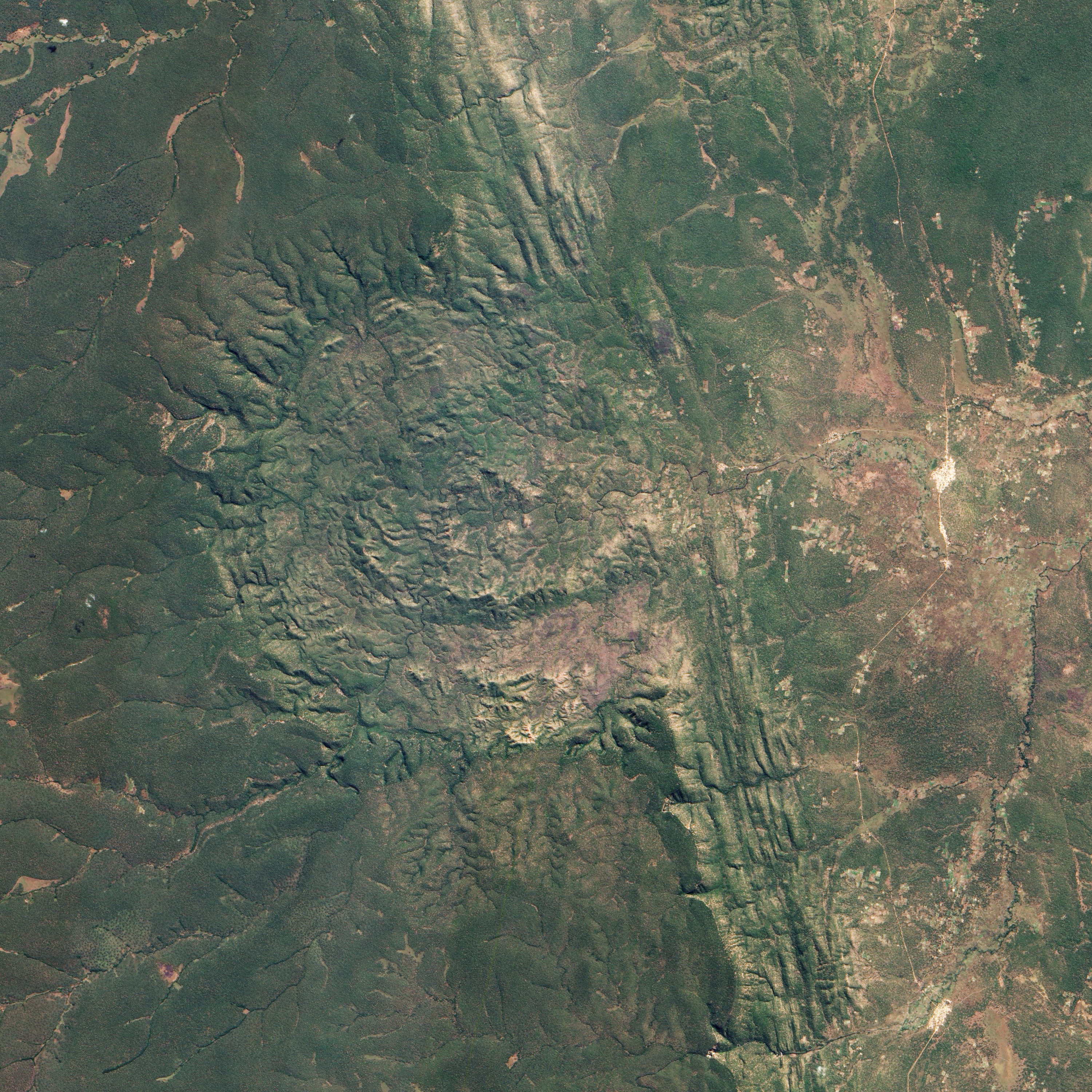
Luizi Crater, Democratic Republic of the Congo


acquired June 2, 2012 download large image (4 MB, JPEG, 3000x3000)


Impact craters can be tough to detect from the ground, especially if they are situated in remote locations and covered by vegetation. Both factors hampered understanding of the Luizi Structure, located in southeastern Congo. The crater is covered by grasses up to a meter (3 feet) high, and tucked away in central Africa.

The Advanced Land Imager (ALI) on NASA’s Earth Observing-1 (EO-1) satellite captured this natural-color image of Luizi on June 2, 2012. It is not perfectly round, but instead fills a semicircular basin where vegetation carpets the complicated topography.

A mention of Luizi made it into a geological report in 1919, but the feature remained unexplored for decades. Satellite imagery of the structure from the 1990s inspired an international team of geologists to look more closely. In 2011, they announced their findings.

Satellite imagery suggested that Luizi might be an impact crater, but volcanoes and even salt domes can form structures that look like impact craters, so the researchers had to go into the field. They found shatter cones, and microscopic analysis of rock samples collected from the site revealed shocked quartz grains. Both shatter cones and shocked quartz are considered strong evidence of meteorite impacts.

Impact craters can be simple or complex. While simple craters have uncomplicated bowl shapes, complex craters sport features that can be counterintuitive, such as inner rings and central peaks. Geologists have linked both crater types to the action of high-velocity impacts.

The researchers studying Luizi reported that the crater spans about 17 kilometers (11 miles) in diameter, with an intermittent ring about 5.2 kilometers (3.2 miles) across, and a smaller, center ring about 2 kilometers (1.2 miles) across. Around the perimeter of the crater, a rim rises approximately 300 to 350 meters (980 to 1,150 feet) above the interior. In short, Luizi is a well-preserved, moderately sized, complex crater.

Exactly when Luizi formed is hard to answer. The researchers estimate that nearby rocks are 575 million years old—more than 300 million years older than the first dinosaurs. But besides knowing that the impact can’t be older than the rock layers it disrupted, the geologists can’t yet say when the impact occurred. Whenever the meteorite arrived, it may have been moving as fast as 72,000 kilometers (45,000 miles) per hour.

Related Resources
Department of Earth Science and Engineering. (2012) The formation of complex craters. Imperial College, London. Accessed June 8, 2012.
Ferrière, L., Lubala, F.R.T., Osinski, G.R., Kaseti, P.K. (2011) The Luizi Structure (Democratic Republic of Congo) — First confirmed meteorite impact crater in Central Africa. 42nd Lunar and Planetary Science Conference, held March 7–11, 2011 at The Woodlands, Texas.
Ferrière, L., Osinski, G.R. (2011) The new Luizi Impact Structure (Democratic Republic of Congo) and implications for central peak and peak ring formation. 42nd Lunar and Planetary Science Conference, held March 7–11, 2011 at The Woodlands, Texas.
Jaggard, V. (2011, March 8) Huge impact crater found in remote Congo. Accessed June 8, 2012.

NASA Earth Observatory image by Jesse Allen and Robert Simmon, using Advanced Land Imager data from the NASA EO-1 team. Caption by Michon Scott.