
ORIGINAL: NASA
July 17, 2012

acquired June 25 - July 10, 2012
download large image (5 MB, JPEG, 3480x2234)

Farmers across the United States hoped for rain in July 2012 as a drought of historic proportions parched key commodity crops, including corn, soybeans, and wheat. On July 11, the United States Department of Agriculture announced that more than 1,000 counties in 26 states qualified as natural disaster areas—the largest total area ever declared a disaster zone by the agency.
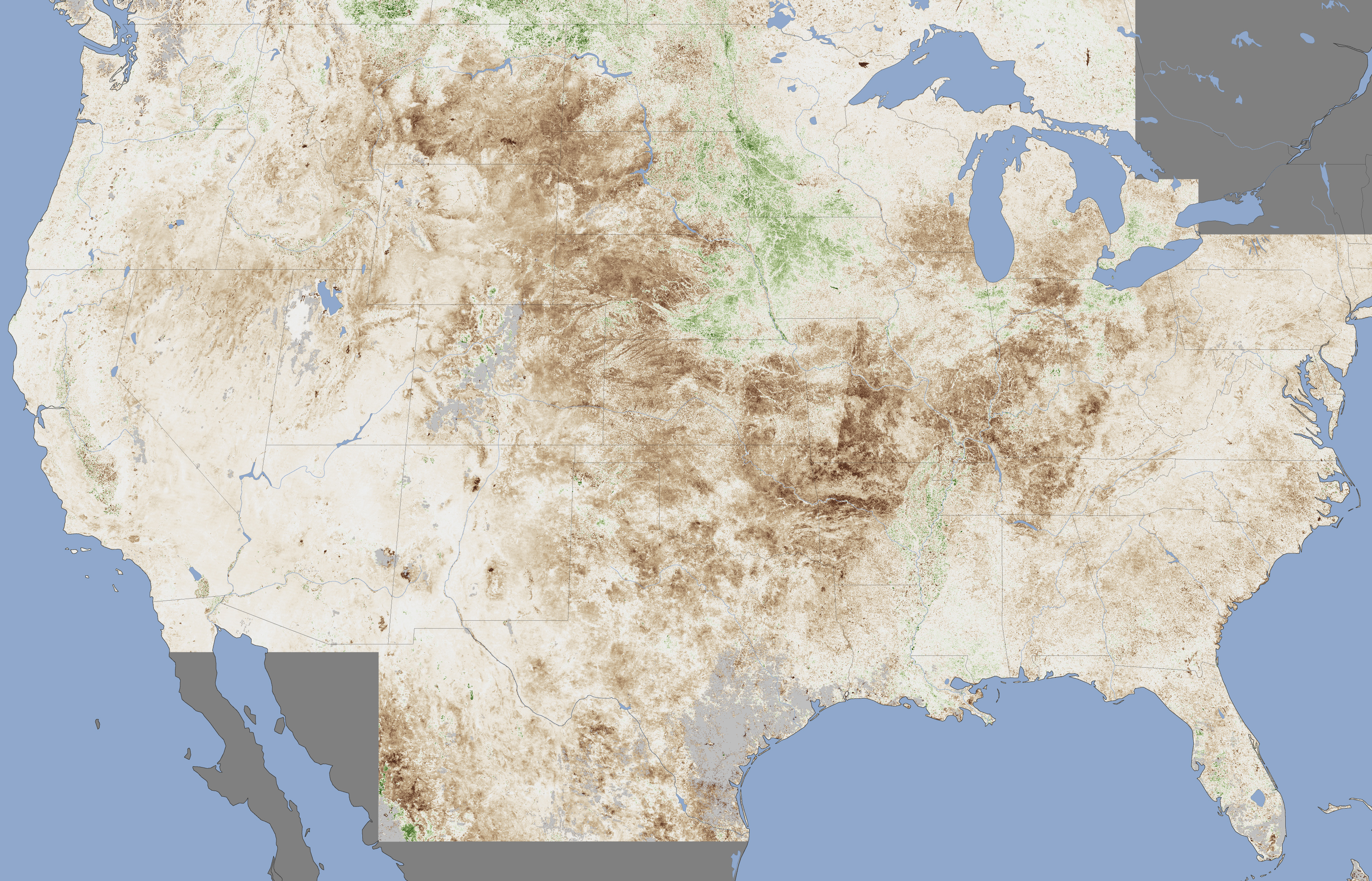
The extent of the damage to crops is depicted in this vegetation anomaly map based on data from the Moderate Resolution Imaging Spectroradiometer (MODIS) on NASA’s Terra satellite. The map contrasts plant health in the central United States between June 25 and July 10, 2012, against the average conditions between 2002 and 2012. Brown areas show where plant growth was less vigorous than normal; cream colors depict normal levels of growth; and green indicates abnormally lush vegetation. Data was not available in the gray areas due to snow or cloud cover. The image is based on the Normalized Difference Vegetation Index (NDVI), a measure of how much plant leaves absorb visible light and reflect infrared light. Drought-stressed vegetation reflects more visible light and less infrared than healthy vegetation.
The most severe damage to crops appears to be centered on Missouri, Arkansas, Oklahoma, Texas, Kansas, Nebraska, and South Dakota. Crops in much of the upper Midwest—southern Wisconsin, Michigan, Indiana, southern Illinois, western Kentucky, and western Tennessee—also show signs of strain. States in the Mountain West that are in the midst of a busy wildfire season—Montana, Wyoming, and Colorado—have also experienced marked declines in the health of vegetation. The drought has been less severe in Iowa, a key corn-growing state.
This drought, like all extreme weather events, has its direct cause in a complex set of atmospheric conditions that produce short-term weather. However, weather occurs within the broader context of climate, and there’s widespread agreement among scientists that the climate is changing due to human activity.
According to a recent IPCC report on extreme weather, there is “medium confidence” that droughts have grown longer and more severe in some parts of the world since 1950, particularly in southern Europe and West Africa. However, the trends appear to be the reverse for droughts in central North America and northwestern Australia. Overall, the scientists who prepared the IPCC report assert a medium level of confidence in their ability to attribute observed changes in drought patterns to human activity.
References
Atlantic Wire. (2012, July 12). U.S. Declares the Largest National Disaster Area Ever Due to Drought. Accessed July 16, 2012.
Climate Central. (2012, July 13). Midwest to Mid-Atlantic Bracing for Onslaught of Heat. Accessed July 16, 2012.
NASA Earth Observatory. (2010, June 3). Global Warming.
USDA. (2012, July 11). USDA Announces Streamlined Disaster Designation Process with Lower Emergency Loan Rates and Greater CRP Flexibility in Disaster Areas. Accessed July 16, 2012.
U.S. Drought Monitor. (2012, July). U.S. Drought Monitor: July 10 (pdf). Accessed July 16, 2012.
Further Reading
Farm Futures. (2012, July 14). Satellite Imagery Reveals Widespread Farm Crop Stress. Accessed July 16, 2012.
IPCC. (2012, March 19). Managing the Risks of Extreme Events and Disasters to Advance Climage Change Adaptation. Accessed July 16, 2012.
NOAA. (2012). State of the Climate National Overview: June. Accessed July 16, 2012.
Peterson, T. (2012, July). Explaining Extreme Events of 2011 from a Climate Perspective. Bulletin of the American Meteorological Society.
NASA Earth Observatory image by Jesse Allen, Earth Observatory,using data provided by Inbal Reshef, Global Agricultural Monitoring Project. Caption by Adam Voiland.Instrument: Terra - MODIS
No hay comentarios:
Publicar un comentario
Nota: solo los miembros de este blog pueden publicar comentarios.